Stourport-on-Severn
| Stourport-on-Severn | |
(c) P L Chadwick, CC BY-SA 2.0 | |
| Land | |
|---|---|
| Riksdel | England |
| Region | West Midlands |
| Ceremoniellt grevskap | Worcestershire |
| Administrativt grevskap | Worcestershire |
| Distrikt | Wyre Forest |
| Koordinater | 52°20′25″N 2°16′37″V / 52.3404°N 2.2769°V |
| Tidszon | GMT (UTC+0) |
| Postnummerområde | DY13 |
| Riktnummer | 01299 |
| Geonames | 2636767 7296196 |
Stourport-on-Severn är en stad och civil parish i Wyre Forest i Worcestershire i England. Orten har 18 889 invånare (2001).[1]
Referenser
- ^ KS01 Usual resident population: Census 2001, Key Statistics for urban areas
Media som används på denna webbplats
Författare/Upphovsman: Alexrk2, Licens: CC BY-SA 3.0
Location map of the United Kingdom
Shiny red button/marker widget. Used to mark the location of something such as a tourist attraction.
(c) P L Chadwick, CC BY-SA 2.0
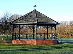
Bandstand, Riverside Meadows, Stourport-on-Severn. In the warmer months of the year, Riverside Meadows is a very popular area with both local residents and the many tourists who visit the town. There is a nice walk alongside the river, plenty of seats, and many facilities for children. 1625954.


