Stockton, Kansas
| Stockton | |
| city | |
| Land | |
|---|---|
| Delstat | Kansas |
| County | Rooks County |
| Höjdläge | 549 m ö.h. |
| Koordinater | 39°26′17″N 99°15′54″V / 39.43806°N 99.26500°V |
| Yta | 5,8 km² (2010) |
| - land | 5,8 km² |
| - vatten | 0,0 km² |
| Folkmängd | 1 329 (2010) |
| Befolkningstäthet | 229 invånare/km² |
| Tidszon | CST (UTC-6) |
| - sommartid | CDT (UTC-5) |
| ZIP-kod | 67669 |
| Riktnummer | 785 |
| FIPS | 2068350 |
| Geonames | 4048488 |
Ortens läge i Kansas | |
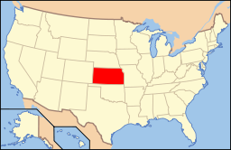
Kansas läge i USA | |
| Webbplats: https://www.stocktonks.com/ | |
Stockton är administrativ huvudort i Rooks County i Kansas.[1] Rooks County grundades år 1872 och Stockton besegrade Rooks Centre i omröstningen om countyts huvudort 95–52. Ortnamnet har med boskap att göra, även Stocktown och Stockville föreslogs.[2]
Källor
- ^ Profile for Stockton, Kansas Arkiverad 8 maj 2016 hämtat från the Wayback Machine.. ePodunk. Läst 12 april 2016.
- ^ A Brief History of Stockton. Solomon Valley Highway Heritage Alliance. Läst 12 april 2016.
Externa länkar
|
Media som används på denna webbplats
Författare/Upphovsman: Alexrk2, Licens: CC BY 3.0
Den här Det karta skapades med GeoTools.
Shiny red button/marker widget. Used to mark the location of something such as a tourist attraction.
Författare/Upphovsman: This version: uploader
Base versions this one is derived from: originally created by en:User:Wapcaplet, Licens: CC BY 2.0
Map of USA with Kansas highlighted
Författare/Upphovsman: Ammodramus, Licens: CC0
Building at 503 Main Street in Stockton, Kansas; to the west (right) is an empty lot at the corner of Main and Walnut, where the Rooks County Record building stood at 501 Main.


