Stirling (kommun)
| Stirling | |
| Kommun | |
| Land | |
|---|---|
| Riksdel | Skottland |
| Administrativ huvudort | Stirling |
| Yta | 2 186 km²[1] |
| Folkmängd | 92 530 (2022)[2] |
| Befolkningstäthet | 42 invånare/km² |
| Tidszon | GMT (UTC+0) |
| - sommartid | BST (UTC+1) |
| ISO 3166-2-kod | GB-STG |
| GSS-kod | S12000030 |
| Geonames | 2636909 |
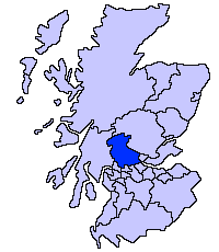
Stirling är en av Skottlands kommuner. Kommunen gränsar till Clackmannanshire, Falkirk, Perth and Kinross, Argyll and Bute, East Dunbartonshire och West Dunbartonshire. Centralort är Stirling. Kommunen täcker större delen av det traditionella grevskapet Stirlingshire och den sydvästra delen av Perthshire. Tillsammans med Falkirks kommun utgör Stirlings kommun det ceremoniella ståthållarskapet Stirling and Falkirk.
Orter
- Aberfoyle
- Bannockburn
- Boreland
- Bridge of Allan
- Callander
- Crianlarich
- Doune
- Dunblane
- Killin
- Lochearnhead
- Stirling
- Thornhill
Källor
- ^ ”Estimates of the population for the UK, England, Wales, Scotland, and Northern Ireland (Mid-2022)” (på engelska) (xls). Landyta, avrundad till hela km². Office for National Statistics. 26 mars 2024. https://www.ons.gov.uk/peoplepopulationandcommunity/populationandmigration/populationestimates/datasets/populationestimatesforukenglandandwalesscotlandandnorthernireland. Läst 25 juni 2024.
- ^ ”Estimates of the population for the UK, England, Wales, Scotland, and Northern Ireland (Mid-2022)” (på engelska) (xls). Office for National Statistics. 26 mars 2024. https://www.ons.gov.uk/peoplepopulationandcommunity/populationandmigration/populationestimates/datasets/populationestimatesforukenglandandwalesscotlandandnorthernireland. Läst 25 juni 2024.
Media som används på denna webbplats
Författare/Upphovsman: Brian Gratwicke from DC, USA, Licens: CC BY 2.0
Stirling castle view of town


