Stevensville, Montana
| Stevensville | |
| town | |
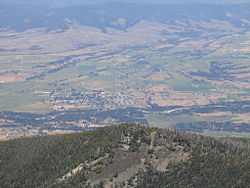
Utsikt från Saint Mary's Peak. | |
| Land | |
|---|---|
| Delstat | Montana |
| County | Ravalli County |
| Höjdläge | 1 013 m ö.h. |
| Koordinater | 46°30′36″N 114°5′35″V / 46.51000°N 114.09306°V |
| Yta | 2,59 km² (2010) |
| - land | 2,54 km² |
| - vatten | 0,05 km² |
| Folkmängd | 1 809 (2010) |
| Befolkningstäthet | 712 invånare/km² |
| Tidszon | MST (UTC-7) |
| - sommartid | MDT (UTC-6) |
| ZIP-kod | 59870 |
| FIPS | 3071200 |
| Geonames | 5680485 |
Ortens läge i Montana | |
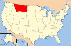
Montanas läge i USA | |
Stevensville är en stad i Ravalli County i delstaten Montana, USA. Staden hade vid folkräkningen år 2000 1 553 invånare. Den har enligt United States Census Bureau en area på totalt 1,3 km², allt är land.
Media som används på denna webbplats
Shiny red button/marker widget. Used to mark the location of something such as a tourist attraction.
Författare/Upphovsman: This version: uploader
Base versions this one is derived from: originally created by en:User:Wapcaplet, Licens: CC BY 2.0
Map of U.S. with Montana highlighted
Författare/Upphovsman: Benjamin Courteau, Licens: CC BY-SA 4.0
View of the town of Stevensville, the Bitterroot River, and the Bitterroot Valley — from St. Mary's Peak in the Bitterroot Mountains Range.
- Located in the Bitterroot National Forest, Ravalli County, Montana.
Författare/Upphovsman: Alexrk2, Licens: CC BY 3.0
Location map of Montana, USA


