Stephenson County
| Stephenson County | |
| County | |
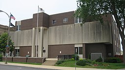
Stephenson Countys domstolshus i Freeport. | |
| Land | |
|---|---|
| Delstat | |
| Huvudort | Freeport |
| Största stad | Freeport |
| Area | 1 463 km² (2010)[1] |
| - land | 1 462 km² (100%) |
| - vatten | 1,4 km² (0%) |
| Folkmängd | 47 711 (2010)[2] |
| Befolkningstäthet | 33 invånare/km² |
| Grundat | 1837 |
| - uppkallat efter | Benjamin Stephenson |
| Tidszon | CST (UTC-6) |
| - sommartid | CDT (UTC-5) |
| FIPS-kod | 17177 |
| Geonames | 4912492 |
Läge i delstaten Illinois. | |
Delstatens läge i USA. | |
| Webbplats: http://www.co.stephenson.il.us/ | |
Stephenson County är ett county i delstaten Illinois, USA. År 2010 hade countyt 47 711 invånare. Den administrativa huvudorten (county seat) är Freeport.
Geografi
Enligt United States Census Bureau har countyt en total area på 1 463 km². 1 462 km² av den arean är land och 1 km² är vatten.
Angränsande countyn
- Green County, Wisconsin - nord
- Winnebago County - öst
- Ogle County - sydost
- Carroll County - sydväst
- Jo Daviess County - väst
- Lafayette County, Wisconsin - nordväst
Orter
Referenser
- ^ ”2010 Census U.S. Gazetteer Files for Counties”. U.S. Census Bureau. Arkiverad från originalet den 5 juli 2012. https://www.webcitation.org/68vYLbou5?url=http://www.census.gov/geo/www/gazetteer/files/Gaz_counties_national.txt. Läst 5 juli 2012.
- ^ ”State & County QuickFacts, Stephenson County, Illinois” (på engelska). U.S. Census Bureau. Arkiverad från originalet den 20 juli 2011. https://www.webcitation.org/60JWwTwYl?url=http://quickfacts.census.gov/qfd/states/17/17177.html. Läst 6 juli 2011.
|
Media som används på denna webbplats
This is a locator map showing Stephenson County in Illinois. For more information, see Commons:United States county locator maps.
Författare/Upphovsman: This version: uploader
Base versions this one is derived from: originally created by en:User:Wapcaplet, Licens: CC BY 2.0
Map of USA with Illinois highlighted
Front of the Stephenson County Courthouse, located in the block bounded by Stephenson Street, Van Buren Avenue, Exchange Street, and Galena Avenue in Freeport, Illinois, United States. Built in 1974, it replaced an earlier courthouse that was listed on the National Register of Historic Places in the same year, and although destroyed more than forty years ago, it has not yet been removed from the Register.


