Stanthorpe
| Stanthorpe | |
| Ort | |
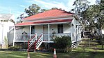
 Stanthorpe Post Office | |
| Land | |
|---|---|
| Delstat | Queensland |
| Kommun | Southern Downs |
| Höjdläge | 796 m ö.h. |
| Koordinater | 28°39′15″S 151°56′02″Ö / 28.65425°S 151.93388°Ö |
| Folkmängd | 4 695 (2014-07-10)[1] |
| Tidszon | AEST (UTC+10) |
| Geonames | 2148507 |
 | |
_taken_from_Mt_Marlay_lookout%2c_Lock_Street_Stanthorpe_Queensland_Australia.jpg)
Stanthorpe är en ort i Australien.[1] Den ligger i kommunen Southern Downs och delstaten Queensland, omkring 170 kilometer sydväst om delstatshuvudstaden Brisbane. Antalet invånare är 4 695.[1]
Stanthorpe är byggt vid Quart Pot Creek, som slingrar sig från sydost genom stadens centrum och ut därifrån åt sydväst, där den födar samman med where Spring Creek och bildar Severn River.
Staden grundades 1872 på grund av brytning av tenn, och hette ursprungligen samma som floden, Quart Pot Creek.
Stanthorpe får sitt vatten från Storm King Dam.
Runt Stanthorpe är det mycket glesbefolkat, med 4 invånare per kvadratkilometer. Stanthorpe är det största samhället i trakten.
Bildgalleri
El Arish, k-märkt byggnad

El Arish, omkring 1920

Park vid Quart_Pot_Creek

Stanthorpe library and art gallery, 2015

Old Stanthorpe Shire Council Chambers, byggt 1914, nu del av Stanthorpe Heritage Museum
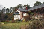
North Maryvale School Residence

Brass monkey vid Stanthorpes Post Office Square

Quart Pot Creak Bridge
Källor
- ^ [a b c] Stanthorpe hos GeoNames.Org (cc-by); post uppdaterad 2014-07-10; databasdump nerladdad 2015-12-01
Media som används på denna webbplats

Författare/Upphovsman: , Licens: CC BY-SA 3.0
Relief map of Australia, including the borders of the states of the Commonwealth of Australia

Shiny red button/marker widget. Used to mark the location of something such as a tourist attraction.

Författare/Upphovsman: Vmenkov, Licens: CC BY-SA 3.0
The brass monkey (and some balls) in Post Office Square, Stanthorpe, Queensland.

Författare/Upphovsman: Kerry Raymond, Licens: CC BY 4.0
Quart Pot Creek Rail Bridge, viewed from upstream, 2015

Författare/Upphovsman: Kerry Raymond, Licens: CC BY 4.0
Old Stanthorpe Shire Council Chambers. Built in 1914, now part of the Stanthorpe Heritage Museum

House known as El Arish at Stanthorpe, ca. 1920. This was the residence of the parents of Charles Chauvel in Stanthorpe. The house is a large, Queenslander style construction with wide verandahs and bay windows in the front. A rail and wire fence with some pickets surround the house.
.jpg)
Stanthorpe township (south-west aspect) taken from Mt Marlay lookout, Lock Street Stanthorpe Queensland Australia.

Författare/Upphovsman: Kerry Raymond, Licens: CC BY 4.0
Parks around Quart Pot Creek, Stanthorpe, 2015
Författare/Upphovsman: Kerry Raymond, Licens: CC BY 4.0
Stanthorpe Post Office, north-west corner Maryland and Railway Streets, Stanthorpe, 2015

Författare/Upphovsman: Kerry Raymond, Licens: CC BY 4.0
North Maryvale School Residence, built 1894. Relocated to Stanthorpe Heritage Museum.

Författare/Upphovsman: Kerry Raymond, Licens: CC BY 4.0
Stanthorpe library and art gallery, 2015, operated by the Southern Downs Regional Council