Staffordshire
| Staffordshire | ||
| Ceremoniellt grevskap | ||
(c) Valerie McGlinchey, CC BY-SA 2.0 uk Omfattande keramiktillverkning har traditionellt bedrivits i Staffordshire, och grevskapet har givit namn till Staffordshire-porslin (här exemplifierat av en tekanna med kinesiskt mönster från Josiah Wedgwoods fabrik). | ||
| ||
| Land | ||
|---|---|---|
| Riksdel | England | |
| Region | West Midlands | |
| Ingående distrikt | Tamworth, Lichfield, Cannock Chase, South Staffordshire, Stafford, Newcastle-under-Lyme, Staffordshire Moorlands, East Staffordshire, Stoke-on-Trent (enhetskommun) | |
| Yta | 2 713 km²[1] | |
| Folkmängd | 1 146 249 (2022)[2] | |
| Befolkningstäthet | 423 invånare/km² | |
| Tidszon | GMT (UTC+0) | |
| - sommartid | BST (UTC+1) | |
| Geonames | 11609018 | |
| Staffordshire | |
| Administrativt grevskap | |
(c) Val Vannet, CC BY-SA 2.0 | |
| Land | |
|---|---|
| Riksdel | England |
| Region | West Midlands |
| Ingående distrikt | Tamworth, Lichfield, Cannock Chase, South Staffordshire, Stafford, Newcastle-under-Lyme, Staffordshire Moorlands, East Staffordshire |
| Administrativ huvudort | Stafford |
| Yta | 2 620 km²[1] |
| Folkmängd | 886 284 (2022)[2] |
| Befolkningstäthet | 338 invånare/km² |
| Tidszon | GMT (UTC+0) |
| - sommartid | BST (UTC+1) |
| GSS-kod | E10000028 |
| Geonames | 11609018 |
Staffordshire är ett ceremoniellt och administrativt grevskap i West Midlands, England. Den största staden är Stoke-on-Trent, som inte tillhör det administrativa grevskapet. Andra större orter är Lichfield, Stafford, Burton upon Trent, Cannock, Newcastle-under-Lyme och Tamworth. Grevskapet var fram till 1974 något större än det nuvarande och omfattade bland annat Wolverhampton, Walsall och West Bromwich, som numera tillhör storstadsområdet West Midlands.
Landskapet i norra och södra Staffordshire är bergigt medan de centrala delarna består av lågland. Floden Trent som har sin källa i Staffordshire är en av Englands största floder. I Staffordshire utvinns kol- och järnfyndigheter.
Administrativ indelning
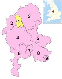
Det administrativa grevskapet Staffordshire omfattar hela det ceremoniella grevskapet Staffordshire med undantag för det område som administreras av enhetskommunen Stoke-on-Trent.
| Nr | Distrikt / Enhetskommun | Administrativt grevskap | Distrikt i det ceremoniella grevskapet Staffordshire |
|---|---|---|---|
| 1 | Stoke-on-Trent |  Rött: Administrativa grevskapet Staffordshire Gult: Enhetskommunen Stoke-on-Trent | |
| 2 | Newcastle-under-Lyme | Staffordshire | |
| 3 | Staffordshire Moorlands | ||
| 4 | Stafford | ||
| 5 | East Staffordshire | ||
| 6 | South Staffordshire | ||
| 7 | Cannock Chase | ||
| 8 | Lichfield | ||
| 9 | Tamworth | ||
Källor
- ^ [a b] ”Estimates of the population for the UK, England, Wales, Scotland, and Northern Ireland (Mid-2022)” (på engelska) (xls). Landyta, avrundad till hela km². Office for National Statistics. 26 mars 2024. https://www.ons.gov.uk/peoplepopulationandcommunity/populationandmigration/populationestimates/datasets/populationestimatesforukenglandandwalesscotlandandnorthernireland. Läst 25 juni 2024.
- ^ [a b] ”Estimates of the population for the UK, England, Wales, Scotland, and Northern Ireland (Mid-2022)” (på engelska) (xls). Office for National Statistics. 26 mars 2024. https://www.ons.gov.uk/peoplepopulationandcommunity/populationandmigration/populationestimates/datasets/populationestimatesforukenglandandwalesscotlandandnorthernireland. Läst 25 juni 2024.
Externa länkar
 Wikimedia Commons har media som rör Staffordshire.
|
Media som används på denna webbplats
Författare/Upphovsman: Rcsprinter123, Licens: CC BY 3.0
Numbered districts of Staffordshire county. Derived from File:Staffordshire UK district map (blank).svg, Nilfanion.
Författare/Upphovsman: Nilfanion, Licens: CC BY-SA 3.0
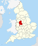
Location of the ceremonial county of Staffordshire within England.
(c) Valerie McGlinchey, CC BY-SA 2.0 uk
Teapot with Chinese Flowers
Staffordshire, about 1820
Wedgwood\'s factory
The county flag of Staffordshire


