St. Paul, Oregon
| St. Paul | |
| Stad (city) | |
| Land | |
|---|---|
| Delstat | |
| County | Marion County |
| Höjdläge | 51 m ö.h. |
| Koordinater | 45°12′40″N 122°58′36″V / 45.21111°N 122.97667°V |
| Area | 0,76 km² (2010)[2] |
| Folkmängd | 434 (2020)[3] |
| Befolkningstäthet | 571 invånare/km² |
| Grundad | 1901[1] |
| Tidszon | PST (UTC-8) |
| - sommartid | PDT (UTC-7) |
| ZIP-kod | 97137 |
| Riktnummer | 503 och 971 |
| GNIS-kod | 1163248 |
| Geonames | 5750110 |
Översiktskarta | |
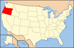
Oregons läge i USA | |
| Wikimedia Commons: St. Paul, Oregon | |
| Webbplats: https://www.stpauloregon.org/ | |
| Redigera Wikidata | |
St. Paul är en ort i Marion County i delstaten Oregon, USA.
Referenser
- ^ hämtat från: engelskspråkiga Wikipedia.[källa från Wikidata]
- ^ United States Census Bureau, 2010 U.S. Gazetteer Files, United States Census Bureau, 2010, läst: 9 juli 2020.[källa från Wikidata]
- ^ United States Census Bureau (red.), USA:s folkräkning 2020, läs online, läst: 1 januari 2022.[källa från Wikidata]
Media som används på denna webbplats
Författare/Upphovsman: Huebi, Licens: CC BY 2.0
Map of United States with Oregon highlighted.
Författare/Upphovsman: Arkyan, Licens: CC BY-SA 3.0
This map shows the incorporated and unincorporated areas in Marion County, Oregon, highlighting St. Paul in red. It was created with a custom script with US Census Bureau data and modified with Inkscape.
Flag of Oregon (obverse): The flag was adopted by the state on February 26, 1925.[1] The state seal was decided in 1903.[2][3]
Författare/Upphovsman: M.O. Stevens, Licens: CC BY-SA 3.0
U.S. Bank branch in old brick building in St. Paul, Oregon, USA


