St. Johns, Michigan
| St. Johns | |
| city | |
| Land | |
|---|---|
| Delstat | Michigan |
| County | Clinton County |
| Höjdläge | 241 m ö.h. |
| Koordinater | 43°0′4″N 84°33′33″V / 43.00111°N 84.55917°V |
| Yta | 10,0 km² (2010) |
| - land | 10,0 km² |
| - vatten | 0,0 km² |
| Folkmängd | 7 865 (2010) |
| Befolkningstäthet | 787 invånare/km² |
| Tidszon | EST (UTC-5) |
| - sommartid | EDT (UTC-4) |
| FIPS | 2670940 |
Ortens läge i Michigan | |
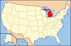
Michigans läge i USA | |
| Webbplats: http://www.ci.saint-johns.mi.us/ | |
St. Johns är administrativ huvudort i Clinton County i den amerikanska delstaten Michigan.[1][2] Enligt 2010 års folkräkning hade St. Johns 7 865 invånare.[3]
Källor
- ^ Michigan County Map with County Seat Cities. Geology.com Geoscience News and Information. Läst 30 augusti 2016.
- ^ Profile for Saint Johns, Michigan Arkiverad 16 september 2016 hämtat från the Wayback Machine.. ePodunk. Läst 30 augusti 2016.
- ^ 2010 Census Population of St. Johns, Michigan Arkiverad 13 september 2016 hämtat från the Wayback Machine.. Census Viewer. Läst 30 augusti 2016.
Media som används på denna webbplats
Shiny red button/marker widget. Used to mark the location of something such as a tourist attraction.
Författare/Upphovsman:
| This media | uploader |
|---|---|
| Original work | en:User:Wapcaplet |
Map of USA with Michigan highlighted
Författare/Upphovsman: GPWITT, Licens: CC BY-SA 3.0
Giles J. Gibbs Building-formerly the Sugar Bowl, 12 N. Clinton Ave. St. Johns
Författare/Upphovsman: Alexrk2, Licens: CC BY 3.0
Den här Det karta skapades med GeoTools.


