St. Francis, Kansas
| St. Francis | |
| city | |
Domstolsbyggnaden | |
| Land | |
|---|---|
| Delstat | Kansas |
| County | Cheyenne County |
| Höjdläge | 1 012 m ö.h. |
| Koordinater | 39°46′20″N 101°48′0″V / 39.77222°N 101.80000°V |
| Yta | 2,25 km² (2010) |
| - land | 2,25 km² |
| - vatten | 0,0 km² |
| Folkmängd | 1 263 (2020)[1] |
| Befolkningstäthet | 561 invånare/km² |
| Tidszon | CST (UTC-6) |
| - sommartid | CDT (UTC-5) |
| ZIP-kod | 67756 |
| Riktnummer | 785 |
| FIPS | 2062175 |
| Geonames | 5446345 |
Ortens läge i Kansas | |
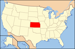
Kansas läge i USA | |
| Webbplats: stfranciskansas.com | |
St. Francis är administrativ huvudort i Cheyenne County i Kansas.[2][3] Enligt 2020 års folkräkning hade St. Francis 1 263 invånare.[1]
Källor
- ^ [a b] ”St. Francis city, Kansas 2020 Decennial Census” (på engelska). United States Census Bureau. https://data.census.gov/profile/St._Francis_city,_Kansas?g=160XX00US2062175. Läst 19 april 2023.
- ^ Kansas County Map with County Seat Cities. Geology.com Geoscience News and Information. Läst 16 maj 2017.
- ^ Profile for Saint Francis, Kansas Arkiverad 19 juni 2017 hämtat från the Wayback Machine.. ePodunk. Läst 16 maj 2017.
Media som används på denna webbplats
Shiny red button/marker widget. Used to mark the location of something such as a tourist attraction.
Författare/Upphovsman: This version: uploader
Base versions this one is derived from: originally created by en:User:Wapcaplet, Licens: CC BY 2.0
Map of USA with Kansas highlighted
Cheyenne County Courthouse on the NRHP since April 26, 2002. At 212 E. Washington St., St. Francis, Kansas. Right next to the St. Francis (Henry Sawhill) City Park, which, believe it or not, I didn't see! A hot dusty town in July at the very western edge of Kansas
Författare/Upphovsman: Alexrk2, Licens: CC BY 3.0
Den här Det karta skapades med GeoTools.


