St. Augustine, Florida
| St. Augustine | |
| city | |
(c) I, Jonathan Zander, CC-BY-SA-3.0 Castillo de San Marcos, St. Augustine, Florida | |
| Land | |
|---|---|
| Delstat | Florida |
| County | St. Johns County |
| Höjdläge | 0 m ö.h. |
| Koordinater | 29°53′45″N 81°18′41″V / 29.89583°N 81.31139°V |
| Yta | 33,1 km² (2010)[1] |
| - land | 24,4 km² |
| - vatten | 8,6 km² |
| Folkmängd | 12 975 (2010)[2] |
| - storstadsområde | 1 277 997 |
| Befolkningstäthet | 532 invånare/km² |
| Styre | Joseph L. Boles |
| Tidszon | EST (UTC-5) |
| - sommartid | EDT (UTC-4) |
| ZIP-kod | 32080, 32084, 32086, 32095[3] |
| FIPS | 1262500 |
| Geonames | 4170894 |
Ortens läge i Florida | |
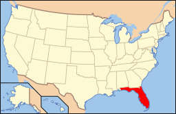
Floridas läge i USA | |
| Webbplats: http://www.staugustinegovernment.com | |
St. Augustine är en stad i St. Johns County i Florida, USA. Den ligger på Floridas östkust vid Atlanten. St. Augustine är administrativ huvudort (county seat) i St. Johns County.
St. Augustine grundades av spanjorer 1565 och är den äldsta staden grundad av europeiska nybyggare på USA:s fastland som varit kontinuerligt bebodd sedan dess.[4] Staden är uppkallad efter Augustinus, som var biskop i Hippo Regius.
Kända personer från St. Augustine
- Edmund Kirby Smith, militär
Se även
- St. Augustine Beach, Florida
- St. Augustine Shores, Florida
- St. Augustine (olika betydelser)
Källor
- ^ ”2010 Census Gazetteer Files”. US Census Bureau. Arkiverad från originalet den 14 juli 2012. https://www.webcitation.org/699nOulzi?url=http://www.census.gov/geo/www/gazetteer/files/Gaz_places_national.txt. Läst 14 juli 2012.
- ^ ”St. Augustine (city), Florida” (på engelska). State & County Quickfacts. U.S. Census Bureau,. Arkiverad från originalet den 14 juli 2012. https://www.webcitation.org/699GWECAe?url=http://quickfacts.census.gov/qfd/states/12/1262500.html. Läst 14 juli 2012.
- ^ ”2010 ZIP Code Tabulation Area (ZCTA) Relationship Files”. U.S. Census Bureau. 29 augusti 2010. Arkiverad från originalet den 25 augusti 2012. https://www.webcitation.org/6ABdwXxbq?url=http://www.census.gov/geo/www/2010census/zcta_rel/zcta_place_rel_10.txt. Läst 25 augusti 2012.
- ^ Den äldsta staden grundad av européer på amerikanskt territorium är dock San Juan, Puerto Rico.
Media som används på denna webbplats
Shiny red button/marker widget. Used to mark the location of something such as a tourist attraction.
Författare/Upphovsman: This version: en:User:Huebi
Base versions this one is derived from: originally created by en:User:Wapcaplet, Licens: CC BY 2.0
Map of USA with Florida highlighted
(c) I, Jonathan Zander, CC-BY-SA-3.0
Panorama of the Castillo de San Marcos fort in St. Augustine, Florida, USA. It was made with Hugin by merging four pictures.


