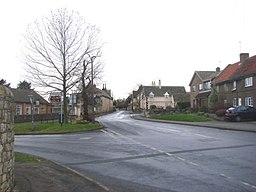
Sprotbrough
| Sprotbrough | |
(c) Bill Henderson, CC BY-SA 2.0 | |
| Land | |
|---|---|
| Riksdel | England |
| Region | Yorkshire och Humber |
| Ceremoniellt grevskap | South Yorkshire |
| Storstadsdistrikt | Doncaster |
| Civil parish | Sprotbrough and Cusworth |
| Koordinater | 53°30′43″N 1°11′14″V / 53.511908°N 1.187166°V |
| Area | 1,13 km² |
| Folkmängd | 3 381 (2016) |
| Befolkningstäthet | 2 992 invånare/km² |
| Tidszon | UTC (UTC+0) |
| - sommartid | BST (UTC+1) |
| Geonames | 2637184 |
Läge i Storbritannien | |
Sprotbrough är en by i civil parish Sprotbrough and Cusworth, i distriktet Doncaster, i grevskapet South Yorkshire, i England. Byn är belägen 23,5 km från Sheffield.[1] Orten har 3 381 invånare (2016).[2] Byn nämndes i Domedagsboken (Domesday Book) år 1086, och kallades då Sproteburg.[3]
Referenser
- ”SPROTBROUGH”. GENUKI. http://www.genuki.org.uk/cgi-bin/maplink?CCC=WRY,GR=SE540020,PLACE=SPROTBROUGH. Läst 2 januari 2018.
- ^ ”Distance from SPROTBROUGH [SE540020”]. GENUKI. http://www.genuki.org.uk/cgi-bin/howfar?CCC=WRY,FROMGR=SE540020,FROMPN=SPROTBROUGH. Läst 2 januari 2018.
- ^ ”Sprotbrough”. City Population. https://www.citypopulation.de/php/uk-england-yorkshireandthehumber.php?cityid=E35000086. Läst 2 januari 2018.
- ^ The National Archives. ”Place name: Sprotbrough”. http://discovery.nationalarchives.gov.uk/details/r/D7312742. Läst 2 januari 2018.
| |||||||||||||||||
Media som används på denna webbplats
Författare/Upphovsman: Alexrk2, Licens: CC BY-SA 3.0
Location map of the United Kingdom
Shiny red button/marker widget. Used to mark the location of something such as a tourist attraction.
(c) Bill Henderson, CC BY-SA 2.0
Main Street, Sprotbrough


