Spokane
| Spokane | ||
| Stad (city) | ||
Vattenfall i Spokane | ||
| ||
| Uppkallad efter: spokanefolket | ||
| Land | ||
|---|---|---|
| Delstat | ||
| County | Spokane County | |
| Höjdläge | 562 m ö.h. | |
| Koordinater | 47°39′26″N 117°25′25″V / 47.65722°N 117.42361°V | |
| Area | 179,99 km² (2020)[2] | |
| - land | 178,09 km² (2020) | |
| - vatten | 1,91 km² (2020) | |
| Folkmängd | 228 989 (2020)[3][4] | |
| Befolkningstäthet | 1 286 invånare/km² | |
| Grundad | 1871 | |
| Borgmästare | Lisa Brown[1] | |
| Tidszon | PST (UTC-8) | |
| - sommartid | PDT (UTC-7) | |
| ZIP-kod | 99201–99220, 99223–99224, 99228, 99251–99252, 99256, 99258, 99260 och 99299 | |
| Riktnummer | 509 | |
| GNIS-kod | 1512683 | |
| Geonames | 5811696 | |
Spokane i Spokane County och Washington | ||
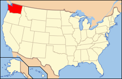
Washingtons läge i USA | ||
| Wikimedia Commons: Spokane, Washington | ||
| Webbplats: http://www.spokanecity.org/ | ||
| Redigera Wikidata | ||
Spokane (engelskt uttal: [ˌspoʊˈkæn]lyssna ) är en stad (city) i Spokane County i delstaten Washington i USA. Staden hade 228 989 invånare, på en yta av 179,99 km² (2020).[5][6] Spokane är administrativ huvudort (county seat) i Spokane County. Staden ligger i delstatens östra delar, cirka 30 kilometer väster om gränsen till Idaho och cirka 370 kilometer öster om Seattle.
Världsutställningen 1974 – Expo '74 – ägde rum i Spokane.[7]
Kända personer från Spokane
- David Eddings, fantasyförfattare
- Sherman Alexie, spokaneindiansk författare
- James R. Holton, meteorolog
- Tyler Johnson, ishockeyspelare
Referenser
- ^ läs online, my.spokanecity.org , läst: 17 juli 2024.[källa från Wikidata]
- ^ Gazetteer Files – 2020 (på engelska), United States Census Bureau, läs online, läst: 16 november 2021.[källa från Wikidata]
- ^ Explore Census Data – Spokane city, Washington (på engelska), United States Census Bureau, läs online, läst: 16 november 2021.[källa från Wikidata]
- ^ United States Census Bureau (red.), USA:s folkräkning 2020, läs online, läst: 1 januari 2022.[källa från Wikidata]
- ^ ”Explore Census Data – Spokane city, Washington” (på engelska). United States Census Bureau. https://data.census.gov/cedsci/profile?g=1600000US5367000. Läst 16 november 2021.
- ^ ”Gazetteer Files – 2020” (på engelska). United States Census Bureau. https://www.census.gov/geographies/reference-files/time-series/geo/gazetteer-files.2020.html. Läst 16 november 2021.
- ^ William T. Youngs (21 april 2010). ”Expo '74 and Earth Day” (på engelska). Inlander. http://www.inlander.com/spokane/expo-74-and-earth-day/Content?oid=2131150. Läst 5 december 2015.
Externa länkar
 Wikimedia Commons har media som rör Spokane.
- Officiell webbplats
| ||||||||||
Media som används på denna webbplats
Författare/Upphovsman: Arkyan, Licens: CC BY-SA 3.0
This map shows the incorporated and unincorporated areas in Spokane County, Washington, highlighting Spokane in red. It was created with a custom script with US Census Bureau data and modified with Inkscape.
Författare/Upphovsman: Martin Kraft, Licens: CC BY-SA 3.0
Upper Spokane Falls, Spokane. Recropped to a 3x2 aspect ratio from the original version by Martin Kraft (http://photo.martinkraft.com/), licensed under CC BY-SA 3.0 on Wikimedia Commons
Författare/Upphovsman: This version: uploader
Base versions this one is derived from: originally created by en:User:Wapcaplet, Licens: CC BY 2.0
Map of USA with Washington highlighted
Flag of Spokane, Washington
(c) Joe Mabel, CC BY-SA 3.0
American English pronunciation of "Spokane," a place name in Washington State, USA. Speaker is originally from New York, but is a 30+ year resident of Washington State.


