South Island (ö i Kenya)
| Den här artikeln har skapats av Lsjbot, ett program (en robot) för automatisk redigering. (2016-10) Artikeln kan innehålla fakta- eller språkfel, eller ett märkligt urval av fakta, källor eller bilder. Mallen kan avlägsnas efter en kontroll av innehållet (vidare information) |
| South Island | |
| Von Hohnel’s Island | |
| Ö | |
| Land | |
|---|---|
| Län | Marsabit |
| Koordinater | 2°37′58″N 36°35′55″Ö / 2.6329°N 36.59871°Ö |
| Tidszon | EAT (UTC+3) |
| Geonames | 179868 |
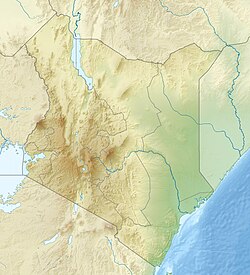
Läge i Kenya | |
South Island är en ö i Kenya i Turkanasjön.[1] Den ligger i länet Marsabit, i den centrala delen av landet, 400 km norr om huvudstaden Nairobi. På ön finns 16 vulkankratrar.[2]
Källor
- ^ South Island hos Geonames.org (cc-by); post uppdaterad 2013-09-06; databasdump nerladdad 2016-09-13
- ^ ”South Island Volcano - John Seach”. Volcano Live. http://www.volcanolive.com/southisland.html. Läst 30 augusti 2017.
Media som används på denna webbplats
Robot icon
Shiny red button/marker widget. Used to mark the location of something such as a tourist attraction.
Författare/Upphovsman: Uwe Dedering, Licens: CC BY-SA 3.0
Location map of Kenya
Equirectangular projection. Strechted by 100.0%. Geographic limits of the map:
- N: 6.0° N
- S: -5.0° N
- W: 33.0° E
- E: 43.0° E
Författare/Upphovsman: User:Doron, Licens: CC BY-SA 3.0
South Island of Lake Turkana, Kenya.


