Sonoma County
| Sonoma County | ||
| County | ||
| ||
| Land | ||
|---|---|---|
| Delstat | ||
| Huvudort | Santa Rosa | |
| Area | 4 579 km² (2010)[1] | |
| - land | 4 081 km² (89%) | |
| - vatten | 498 km² (11%) | |
| Folkmängd | 483 878 (2010)[2] | |
| Befolkningstäthet | 119 invånare/km² | |
| Grundat | 18 februari 1850 | |
| Tidszon | PST (UTC-8) | |
| - sommartid | PDT (UTC-7) | |
| FIPS-kod | 06097 | |
| Geonames | 5397100 | |
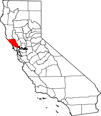
 Läge i delstaten Kalifornien. | ||
Delstatens läge i USA. | ||
| Webbplats: https://sonomacounty.ca.gov | ||
Sonoma County är ett county i Kalifornien i delstaten USA. Administrativ huvudort (county seat) är Santa Rosa.
Geografi
Enligt United States Census Bureau har countyt en total area på 4 579 km². 4 082 km² av den arean är land och 497 km² är vatten.
Angränsande countyn
- Mendocino County, Kalifornien - nord
- Lake County, Kalifornien - nordost
- Napa County, Kalifornien - öst
- Solano County, Kalifornien - sydost
- Marin County, Kalifornien - syd
- Contra Costa County, Kalifornien - sydost
Vindistrikt
Countyt är USA:s mest kända vindistrikt efter Napa Valley. Till skillnad från Napa är dock detta distrikt ett stort och heterogent distrikt med många olika klimat och jordtyper. Totalt omfattar distriktet cirka 17 000 hektar vinodling. Först på 1970-talet utvecklades distriktet till den betydelse det har idag.
Druvor

Kalifornien i allmänhet – och Sonoma County i synnerhet – är hemvist för druvan zinfandel, som i Europa vanligen kallas primitivo. Distriktet är också störst i Kalifornien på pinot noir och chardonnay sett till ordlingsarealer.
Källor
- ^ ”2010 Census U.S. Gazetteer Files for Counties”. U.S. Census Bureau. Arkiverad från originalet den 5 juli 2012. https://www.webcitation.org/68vYLbou5?url=http://www.census.gov/geo/www/gazetteer/files/Gaz_counties_national.txt. Läst 5 juli 2012.
- ^ ”State & County QuickFacts, Sonoma County, Kalifornien” (på engelska). U.S. Census Bureau. Arkiverad från originalet den 20 juli 2011. https://www.webcitation.org/60JRmzTMJ?url=http://quickfacts.census.gov/qfd/states/06/06097.html. Läst 6 juli 2011.
Externa länkar
 Wikimedia Commons har media som rör Sonoma County.
- Sonoma County på Open Directory Project
- Sonoma Countys officiella webbplats
| ||||||||||
|
Media som används på denna webbplats
Författare/Upphovsman: Huebi, Licens: CC BY 2.0
Map of USA with California highlighted
Different version of the seal: http://sonomacounty.ca.gov/images_portal/shell/sonoma_county_logo.png
Flag of California. This version is designed to accurately depict the standard print of the bear as well as adhere to the official flag code regarding the size, position and proportion of the bear, the colors of the flag, and the position and size of the star.
This is a locator map showing Sonoma County in California. For more information, see Commons:United States county locator maps.
Författare/Upphovsman: Anlace, Licens: CC BY-SA 3.0
Photographer: Self Subject: Hood Mountain, Sonoma County, Ca, USA from Sonoma Valley


