Solapur
| Solapur | |
| Sholapur | |
| Stad | |
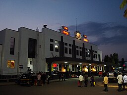
Centralstationen i Solapur. | |
| Land | |
|---|---|
| Delstat | Maharashtra |
| Distrikt | Solapur |
| Koordinater | 17°39′55″N 75°54′27″Ö / 17.66528°N 75.90750°Ö |
| Area | 178,57 km²[1] |
| Folkmängd | 1 014 084 (30 juni 2018)[2] |
| Befolkningstäthet | 5 679 invånare/km² |
| Geonames | 1256436 |
Solapurs läge på karta över Indien. | |
Solapur (eller Sholapur) är en stad i den indiska delstaten Maharashtra. Den är administrativ huvudort för distriktet Solapur och beräknades ha cirka 1 miljon invånare 2018.
Källor
Media som används på denna webbplats
(c) Uwe Dedering på tyska Wikipedia, CC BY-SA 3.0
Location map of India.
Equirectangular projection. Strechted by 106.0%. Geographic limits of the map:
- N: 37.5° N
- S: 5.0° N
- W: 67.0° E
- E: 99.0° E
Shiny red button/marker widget. Used to mark the location of something such as a tourist attraction.
Författare/Upphovsman: Dharmadhyaksha, Licens: CC BY-SA 3.0
Solapur Railway station in evening.


