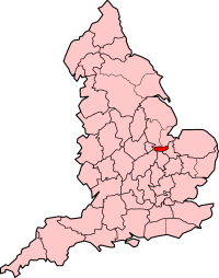
Soke of Peterborough
| Soke of Peterborough | ||
(c) Dave Hitchborne, CC BY-SA 2.0 | ||
| ||
| Land | ||
|---|---|---|
| Riksdel | England | |
| Grevskap | Cambridgeshire Northamptonshire | |
| Koordinater | 52°34′17″N 0°14′32″V / 52.5714°N 0.2421°V | |
| Peterborough | ||
| Grundad | 1889 | |
| Tidszon | UTC (UTC+0) | |
| - sommartid | BST (UTC+1) | |
| Geonames | 2637553 | |
Läge i Storbritannien | ||
Soke of Peterborough var ett grevskap 1889–1965 när det uppgick i Huntingdon and Peterborough och Northamptonshire, i England. Grevskap hade 74 758 invånare år 1961.[1] Peterborough var det administrativa centrumet.
Distrikt
- Barnack
- Peterborough
- Peterborough[2]
Referenser
- ^ ”Population statistics the Soke of Peterborough AdmC through time”. A Vision of Britain through Time. https://visionofbritain.org.uk/unit/10152914/cube/TOT_POP. Läst 31 januari 2024.
- ^ ”Relationships and changes the Soke of Peterborough AdmC through time”. A Vision of Britain through Time. https://visionofbritain.org.uk/unit/10152914. Läst 31 januari 2024.
Externa länkar
 Wikimedia Commons har media som rör Soke of Peterborough.
Media som används på denna webbplats
Författare/Upphovsman: Alexrk2, Licens: CC BY-SA 3.0
Location map of the United Kingdom
Shiny red button/marker widget. Used to mark the location of something such as a tourist attraction.
(c) Dave Hitchborne, CC BY-SA 2.0
The Town Hall, Peterborough The Town Hall stands on Bridge Street.
(c) Morwen from en.wikipedia.org, CC BY-SA 3.0
England Soke of Peterborough 1890
Författare/Upphovsman: unknown, Licens: CC BY-SA 4.0


