Smardale
| Smardale | |
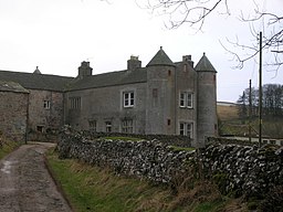
(c) John Darch, CC BY-SA 2.0 Smardale Hall | |
| Land | |
|---|---|
| Riksdel | England |
| Grevskap | Cumbria |
| Enhetskommun | Westmorland and Furness |
| Civil parish | Waitby |
| Koordinater | 54°28′06″N 2°24′06″V / 54.4683°N 2.4016°V |
| Tidszon | UTC (UTC+0) |
| - sommartid | BST (UTC+1) |
| Geonames | 2637614 |
Läge i Storbritannien | |
Smardale är en by (village) i civil parish Waitby, i distriktet Westmorland and Furness, i grevskapet Cumbria,[1] i nordvästra England. Smardale var en civil parish 1866–1894 när det uppgick i Waitby.[2] Civil parish hade 36 invånare år 1891.[3]
Referenser
- ^ http://www.geograph.org.uk/gridref/NY7308
- ^ ”Relationships and changes Smardale Tn/Ch/CP through time”. A Vision of Britain through Time. https://visionofbritain.org.uk/unit/10149988. Läst 17 januari 2022.
- ^ ”Population statistics Smardale Tn/Ch/CP through time”. A Vision of Britain through Time. https://visionofbritain.org.uk/unit/10149988/cube/TOT_POP. Läst 17 januari 2022.
Externa länkar
 Wikimedia Commons har media som rör Smardale.
Media som används på denna webbplats
Författare/Upphovsman: Alexrk2, Licens: CC BY-SA 3.0
Location map of the United Kingdom
Shiny red button/marker widget. Used to mark the location of something such as a tourist attraction.
(c) John Darch, CC BY-SA 2.0
Smardale Hall. Sixteenth century farmhouse with distinctive corner turrets.


