Skallsjö församling
| Skallsjö församling Församling | |
 | |
| Land | Sverige |
|---|---|
| Kommun | Lerums kommun[1] |
| Trossamfund | Svenska kyrkan |
| Stift | Göteborgs stift |
| Bildad | medeltiden |
| Avskild från | Skallsjö socken (1863) |
| Medlemmar | 6 677 (61 %) ()[2] |
| Folkmängd | 10 917 ()[2] |
| Upphov till | Skallsjö distrikt |
| Karta | |
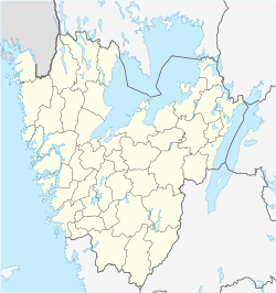
Skallsjö församlings läge i Västra Götalands län. | |
| Koordinat | 57°48′19″N 12°22′47″Ö / 57.805277777778°N 12.379833333333°Ö |
| Utsträckning | SCB:s kartsök |
| Koder, länkar | |
| Församlingskod | 152500 (–) 152501 (–) 152402 (–) 144102 (–) |
| Pastoratskod | 081002 (–) 081810 (–) |
| Kyrkoarkiv | SE/GLA/13468 |
| Redigera Wikidata | |
Skallsjö församling är en församling i Mölndals och Partille kontrakt i Göteborgs stift. Församlingen ligger i Lerums kommun i Västra Götalands län (Västergötland) och utgör ett eget pastorat.
Administrativ historik
Församlingen har medeltida ursprung.
Församlingen var till 1 maj 1924 annexförsamling i pastoratet (Stora) Lundby, Skallsjö och Lerum som även omfattade Angereds församling och Bergums församling till slutet av 1500-talet och från 1694 till 27 oktober 1865. Från 1 maj 1924 till 1962 annexförsamling i pastoratet Stora Lundby och Skallsjö. Församlingen utgör sedan 1962 ett eget pastorat.[3]
Kyrkobyggnader
Se även
Källor
- ^ läst: 15 augusti 2018.[källa från Wikidata]
- ^ [a b] Medlemmar i Svenska kyrkan i förhållande till folkmängd den 31.12.2019 per församling, kommun och län samt riket, Svenska kyrkan, läs online.[källa från Wikidata]
- ^ ”Förteckning (Sveriges församlingar genom tiderna)”. Skatteverket. 1989. http://www.skatteverket.se/privat/folkbokforing/omfolkbokforing/folkbokforingigaridag/sverigesforsamlingargenomtiderna/forteckning.4.18e1b10334ebe8bc80003999.html. Läst 17 december 2013.
Externa länkar
| ||||||||||||||||||||||||||||
| ||||||||||||||||
Media som används på denna webbplats
Författare/Upphovsman: Erik Frohne, Licens: CC BY 3.0
Karta över Västra Götaland i Sverige
Equirectangular projection, N / S sträcker sig 190%. Geografiska gränser för kartan:
- N: 59.50° N
- S: 57.10° N
- W: 10.90° E
- E: 15.20° E
Shiny red button/marker widget. Used to mark the location of something such as a tourist attraction.
Författare/Upphovsman: Eskil Malmberg, Licens: CC BY-SA 4.0
Altaret i Skallsjö kyrkoruin.
Författare/Upphovsman:
|
i RAÄ:s bebyggelseregister (BBR). Läs mer i Wikipedia.
Författare/Upphovsman:
|
i RAÄ:s bebyggelseregister (BBR). Läs mer i Wikipedia.


