Sjörröd
| Sjörröd | |
| Tätort | |
Spiggvägen | |
| Land | |
|---|---|
| Landskap | Skåne |
| Län | Skåne län |
| Kommun | Hässleholms kommun |
| Distrikt | Hässleholms distrikt |
| Koordinater | 56°8′24″N 13°43′51″Ö / 56.14000°N 13.73083°Ö |
| Area | 170 hektar (2020)[1] |
| Folkmängd | 1 470 (2020)[1] |
| Befolkningstäthet | 8,6 inv./hektar |
| Tidszon | CET (UTC+1) |
| - sommartid | CEST (UTC+2) |
| Postort | Hässleholm |
| Postnummer | 281 35 |
| Riktnummer | 0451 |
| Tätortskod | T3062[2] |
| Beb.områdeskod | 1293TB110 (1990–)[3] |
| Geonames | 2678779 |
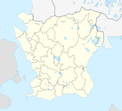
Ortens läge i Skåne län | |
| Wikimedia Commons: Sjörröd | |
| SCB:s bebyggelseområdesavgränsning Redigera Wikidata | |
Sjörröd är en tätort i Hässleholms kommun i Skåne län, belägen vid Finjasjön cirka tre kilometer söder om Hässleholm.
Befolkningsutveckling
| Befolkningsutvecklingen i Sjörröd 1960–2020[4] | ||||
|---|---|---|---|---|
| År | Folkmängd | Areal (ha) | ||
| 1960 | 224 | |||
| 1965 | 202 | |||
| 1990 | 445 | 175 | ||
| 1995 | 478 | 175 | ||
| 2000 | 530 | 188 | ||
| 2005 | 672 | 199 | ||
| 2010 | 1 077 | 213 | ||
| 2015 | 1 169 | 166 | ||
| 2020 | 1 470 | 170 | ||
Anm.: Ej tätort 1970-1980 | ||||
Se även
Källor
- ^ [a b c] Statistiska tätorter 2020, befolkning, landareal, befolkningstäthet per tätort, Statistiska centralbyrån, 24 november 2021, läs online.[källa från Wikidata]
- ^ Befolkning i tätorter 1960-2010, Statistiska centralbyrån, läs online, läst: 7 januari 2014.[källa från Wikidata]
- ^ Kodnyckel för SCB:s statistiska tätorter och småorter - Koppling mellan gammalt och nytt kodsystem, Statistiska centralbyrån, 11 november 2021, läs online.[källa från Wikidata]
- ^ ”Folkmängd och landareal i tätorter, per tätort. Vart femte år 1960 - 2020”. Statistiska centralbyrån. https://www.statistikdatabasen.scb.se/pxweb/sv/ssd/START__MI__MI0810__MI0810A/LandarealTatortN/. Läst 28 maj 2021.
| |||||||||||||||||||||||||
Media som används på denna webbplats
Författare/Upphovsman: Erik Frohne, Licens: CC BY 3.0
Location map of Scania (Skåne) in Sweden
Equirectangular projection, N/S stretching 179 %. Geographic limits of the map:
- N: 56° 37' N
- S: 55° 12' N
- W: 12° 12' E
- E: 15° 00' E
Shiny red button/marker widget. Used to mark the location of something such as a tourist attraction.
Författare/Upphovsman:
|
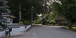
Spiggvägen i Sjörröd utanför Hässleholm.


