Silloth
| Silloth | |
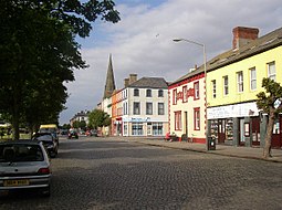
(c) Humphrey Bolton, CC BY-SA 2.0 Criffel Street | |
| Land | |
|---|---|
| Riksdel | England |
| Region | Nordvästra England |
| Ceremoniellt grevskap | Cumbria |
| Enhetskommun | Cumberland |
| Civil parish | Silloth-on-Solway |
| Koordinater | 54°52′07″N 3°23′21″V / 54.8685°N 3.3892°V |
| Folkmängd | 2 932 (2001) |
| Tidszon | UTC (UTC+0) |
| - sommartid | BST (UTC+1) |
| Geonames | 2637836 |
Läge i Storbritannien | |
Silloth[1] är en stad i civil parish Silloth-on-Solway, i kommunen Cumberland, i grevskapet Cumbria, i England. Orten hade 2 932 invånare år 2001.[2] Den har en kyrka.[3][4]
Referenser
- ^ http://www.geograph.org.uk/gridref/NY1153
- ^ KS01 Usual resident population: Census 2001, Key Statistics for urban areas
- ^ http://www.britishlistedbuildings.co.uk/en-71991-christ-church-silloth-on-solway
- ^ http://www.visitcumbria.com/wc/silloth-christ-church.htm
Media som används på denna webbplats
Författare/Upphovsman: Alexrk2, Licens: CC BY-SA 3.0
Location map of the United Kingdom
Shiny red button/marker widget. Used to mark the location of something such as a tourist attraction.
(c) Humphrey Bolton, CC BY-SA 2.0
Original description:
Criffel Street, Silloth
Silloth was developed as a fashionable spa town, but was not very successful, but is now attractive with its bright colour-washed buildings. It was planned by Messrs Hay of Liverpool as a grid of wide tree-lined streets. The main street is Criffel Street, named after the prominent mountain over the Solway Firth. On the seaward side of Criffel Street there is a large green, with pine trees, between the town and the well built Promenade, which gives good views across the Solway. The granite setts are now 'heritage' and a tourist attraction.


