Sikeston
| Sikeston | |
| city | |
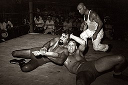
En brottningsmatch i Sikeston år 1938. | |
| Land | |
|---|---|
| Delstat | Missouri |
| County | New Madrid County Scott County |
| Höjdläge | 100 m ö.h. |
| Koordinater | 36°52′46″N 89°35′7″V / 36.87944°N 89.58528°V |
| Yta | 45,3 km² (2010) |
| - land | 44,9 km² |
| - vatten | 0,4 km² |
| Folkmängd | 16 318 (2010) |
| Befolkningstäthet | 363 invånare/km² |
| Tidszon | CST (UTC-6) |
| - sommartid | CDT (UTC-5) |
| ZIP-kod | 63801 |
| FIPS | 2967790 |
| Geonames | 4408672 |
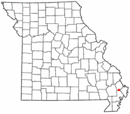
Ortens läge i Missouri | |
Missouris läge i USA | |
| Webbplats: http://www.sikeston.org/ | |
Sikeston är en ort i New Madrid County, och Scott County i Missouri. Orten fick sitt namn efter grundaren John Sikes.[1] Sikeston var av strategisk betydelse under amerikanska inbördeskriget och ockuperades av både nord- och stydstaterna i olika skeden av kriget.[2]
Kända personer från Sikeston
- Kenny Hulshof, politiker
Källor
- ^ Profile for Sikeston, Missouri Arkiverad 6 augusti 2016 hämtat från the Wayback Machine.. ePodunk. Läst 3 juni 2016.
- ^ History of Sikeston. Sikeston, Missouri. Läst 3 juni 2016.
|
Media som används på denna webbplats
Författare/Upphovsman: The original uploader was Catbar på engelska Wikipedia., Licens: CC BY-SA 3.0
Adapted from Wikipedia's MO county maps by Catbar.
A wrestling match performance in Sikeston, Missouri, May 1938. Two wrestlers grapple while the referee (in white, right) looks on. The bearded wrestler is known as Big Tom Towers. Description on photo: "Wrestling match sponsored by American Legion, Sikeston, Missouri."
Författare/Upphovsman: This version: uploader
Base versions this one is derived from: originally created by en:User:Wapcaplet, Licens: CC BY 2.0
Map of USA with Missouri highlighted


