Siglufjörður
| Siglufjörður | |
| Ort | |
| Land | |
|---|---|
| Region | Norðurland eystra |
| Höjdläge | 6 m ö.h. |
| Koordinater | 66°09′07″N 18°54′29″V / 66.15198°N 18.90815°V |
| Folkmängd | 1 176 (2022)[1] |
| Tidszon | UTC (UTC+0) |
| Geonames | 2627130 |
 Läge på Island | |
Siglufjörður är en liten stad på norra Island som växte upp under början av 1900-talet som ett centrum för fisket.[2] Staden har 1 176 invånare (2022)[1] samt flera fiskeindustrier såsom fryserier, fiskkonserver och silloljefabriker. Staden ligger i kommunen Fjallabyggð.
Siglufjörður fick stadsrättigheter år 1918.
Siglufjörður

Kyrkan i Siglufjörður
Referenser
- ^ [a b] SIGLUFJÖRÐUR (Fjallabyggð) - citypopulation.de
- ^ ”Welcome to Siglufjörður” (på engelska). Fjallabyggð. https://www.fjallabyggd.is/port/siglufjardarhofn/welcome-to-sigufjordur. Läst 16 oktober 2022.
Media som används på denna webbplats

Iceland relief map.jpg
Författare/Upphovsman:
Location map of Iceland
Författare/Upphovsman:
- Iceland_location_map.svg: NordNordWest
- derivative work: Виктор В (talk)
Location map of Iceland

Red pog.svg
Shiny red button/marker widget. Used to mark the location of something such as a tourist attraction.
Shiny red button/marker widget. Used to mark the location of something such as a tourist attraction.

The church in the small community of Siglufjörður, Iceland.jpg
Författare/Upphovsman: Jakob Gleby, Licens: CC BY-SA 3.0
A photo of the church in Siglufjörður, with typical Icelandic landscape in the background.
Författare/Upphovsman: Jakob Gleby, Licens: CC BY-SA 3.0
A photo of the church in Siglufjörður, with typical Icelandic landscape in the background.

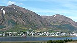
Siglufjörður Overview.jpg
Författare/Upphovsman: Jakob Gleby, Licens: CC BY-SA 3.0
The small community of Siglufjörður in Iceland, with typical Icelandic mountains in the background. The black, small lines on the far right side of the image, on the green mountainside are barriers set up to prevent landslides from reaching the buildings. You can see the church on the lower right side of the image among the other buildings. The photo was taken from an area around the airfield outside Siglufjörður with a Sony video camera.