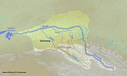
Shulefloden
| Shulefloden (疏勒河) | |
| Shule He, Bulundzir, Shuleh, Bolunzir Gol, Sulei Ho, Hei Ho, Su-lo Ho, Pu-lung-chi-ho, Sulokhe | |
| Vattendrag | |
Karta över Shulefloden | |
| Land | |
|---|---|
| Koordinater | 40°25′00″N 93°46′17″Ö / 40.416618°N 93.771361°Ö |
| Tidszon | BST (UTC+6) |
| Geonames | 1529181 |
Läge i Kina | |
Shulefloden eller Shule He (疏勒河) är en flod i Kina.[1] Floden rinner från Tibetanska högplatån nordväst mot Lop Nor. Den ligger i den nordvästra delen av landet, 2 000 km väster om huvudstaden Peking.
Lämningarna efter kinesiska muren från Handynastin följer Shuleflodens södra strand.[2]
Källor
- ^ Shule He hos Geonames.org (cc-by); post uppdaterad 2012-01-18; databasdump nerladdad 2016-03-31
- ^ ”Great Wall of Three Dynasties in Gansu” (på engelska). China Scenic, Chinese National Geography 中国国家地理. Arkiverad från originalet den 22 februari 2017. https://web.archive.org/web/20170222203803/http://www.chinascenic.com/magazine/great-wall-of-three-dynasties-in-gansu-374.html. Läst 22 februari 2017.
Media som används på denna webbplats
Shiny red button/marker widget. Used to mark the location of something such as a tourist attraction.
Författare/Upphovsman: Uwe Dedering, Licens: CC BY-SA 3.0
Relief Location map of Asia.
- Projection: Lambert azimuthal equal-area projection.
- Area of interest:
- N: 90.0° N
- S: -10.0° N
- W: 45.0° E
- E: 145.0° E
- Projection center:
- NS: 40.0° N
- WE: 95.0° E
- GMT projection: -JA95/50/20.0c
- GMT region: -R45.70461034279053/-25.193892806246794/-158.9850042825966/36.990936559512505r
- GMT region for grdcut: -R-20.0/-26.0/205.0/90.0r
- Relief: SRTM30plus.
- Made with Natural Earth. Free vector and raster map data @ naturalearthdata.com.
Författare/Upphovsman: Shannon, Licens: CC BY-SA 4.0
Map of the Shule River drainage basin in northern China (Basin outline to the northwest approximate)


