Shell, Wyoming
| Shell, Wyoming | |
| CDP | |
| Land | |
|---|---|
| Delstat | |
| County | Big Horn County |
| Höjdläge | 1 285 m ö.h. |
| Koordinater | 44°32′8″N 107°46′45″V / 44.53556°N 107.77917°V |
| Area | 2,96 km² (2010)[1] |
| Folkmängd | 74 (2020)[2] |
| Befolkningstäthet | 25 invånare/km² |
| Tidszon | MST (UTC-7) |
| - sommartid | MDT (UTC-6) |
| ZIP-kod | 82441 |
| GNIS-kod | 1602866 |
| Geonames | 5838148 |
Ortens läge i delstaten | |
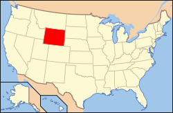
Wyomings läge i USA | |
| Wikimedia Commons: Shell, Wyoming | |
| Redigera Wikidata | |

Shell är en ort (census-designated place) i Big Horn County i norra delen av den amerikanska delstaten Wyoming. Orten ligger i countyts östra del, vid U.S. Route 14 och vattendraget Shell Creek. Befolkningen uppgick till 83 personer vid 2010 års federala folkräkning.
Geografi
Shell ligger vid västra foten av Big Horn Mountains, vid Shell Canyons mynning. Vattendraget Shell Creek rinner från bergen genom orten och rinner härifrån mot sammanflödet med Bighorn River nära Greybull.
Sevärdheter

Orten har sitt namn efter de många fossila skal som finns i trakten. Cloverlyformationen och Morrisonformationen är två internationellt kända fyndplatser för många dinosauriefossil, och vid Red Gulch finns en samling mycket välbevarade dinosauriefotavtryck från mellersta juraperioden. Ett känt fynd vid Morrisonformationen är "Big Al", ett välbevarat fossil av en ung Allosaurus, som idag finns på Museum of the Rockies i Bozeman, Montana.
Utbildning och forskning
Iowa State University har en fältstation i Shell.
Källor
- Den här artikeln är helt eller delvis baserad på material från engelskspråkiga Wikipedia, Shell, Wyoming, 30 mars 2017.
- ^ United States Census Bureau, 2010 U.S. Gazetteer Files, United States Census Bureau, 2010, läst: 9 juli 2020.[källa från Wikidata]
- ^ United States Census Bureau (red.), USA:s folkräkning 2020, läs online, läst: 1 januari 2022.[källa från Wikidata]
| ||||||||||||||||
Media som används på denna webbplats
Shiny red button/marker widget. Used to mark the location of something such as a tourist attraction.
Författare/Upphovsman: Acroterion, Licens: CC BY-SA 4.0
Old Shell Lodge, Shell, Wyoming, USA in 2007
The Red Gulch Dinosaur Tracksite — an interpretive area in the Red Gulch/Alkali National Back Country Byway, in Big Horn County, Wyoming.
- Site of Jurassic dinosaur footprints, protected by the BLM−Bureau of Land Management in Wyoming.
From the My Public Lands Magazine, Summer 2014: "Walking with Giants"
- We follow 167-million-year-old dinosaur tracks in the ancient ocean shores of…Wyoming? You can imagine yourself walking along an ocean shoreline 167 million years ago with dozens of other dinosaurs, looking to pick up a bite of lunch from what washed up on the last high tide. The ground is soft and your feet sink down in the thick ooze, leaving a clear footprint with every step you take.
- The discovery of rare fossil footprints on public lands near the Red Gulch/Alkali National Back Country Byway close to Shell, Wyoming, could alter current views about the Sundance Formation and the paleoenvironment of the Middle Jurassic Period.
- Story by Sarah Beckwith, BLM Wyoming
- Read the story: on.doi.gov/1mC35Ux
Författare/Upphovsman: This version: uploader
Base versions this one is derived from: originally created by en:User:Wapcaplet, Licens: CC BY 2.0
Map of USA with Wyoming highlighted
Författare/Upphovsman: Alexrk, Licens: CC BY 3.0
Den här Det karta skapades med GeoTools.


