Sevenoaks District
| Sevenoaks District | |
| Distrikt | |
| Land | |
|---|---|
| Riksdel | England |
| Region | Sydöstra England |
| Ceremoniellt grevskap | Kent |
| Administrativt grevskap | Kent |
| Koordinater | 51°16′N 0°11′Ö / 51.27°N 0.18°Ö |
| Huvudort | Sevenoaks |
| Area | 369 km²[1] |
| Folkmängd | 121 106 (2022)[2] |
| Befolkningstäthet | 328 invånare/km² |
| Tidszon | UTC (UTC+0) |
| - sommartid | BST (UTC+1) |
| GSS-kod | E07000111 |
| Geonames | 6945814 |
Contains Ordnance Survey data © Crown copyright and database right, CC BY-SA 3.0 Läge i grevskapet Kent | |
Sevenoaks District är ett distrikt (motsvarande kommun) i grevskapet Kent i England, Storbritannien. Distriktet har 121 106 invånare (2022)[2]. Större orter är Sevenoaks och Swanley. Distriktet är indelat i 31 civil parishes.
Källor
- ^ ”Estimates of the population for the UK, England, Wales, Scotland, and Northern Ireland (Mid-2022)” (på engelska) (xls). Landyta, avrundad till hela km². Office for National Statistics. 26 mars 2024. https://www.ons.gov.uk/peoplepopulationandcommunity/populationandmigration/populationestimates/datasets/populationestimatesforukenglandandwalesscotlandandnorthernireland. Läst 25 juni 2024.
- ^ [a b] ”Estimates of the population for the UK, England, Wales, Scotland, and Northern Ireland (Mid-2022)” (på engelska) (xls). Office for National Statistics. 26 mars 2024. https://www.ons.gov.uk/peoplepopulationandcommunity/populationandmigration/populationestimates/datasets/populationestimatesforukenglandandwalesscotlandandnorthernireland. Läst 25 juni 2024.
Media som används på denna webbplats
Författare/Upphovsman: Arriva436, Licens: CC BY 3.0
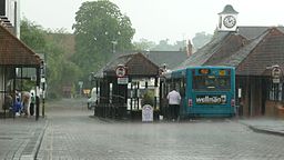
Sevenoaks bus station, Kent, during a torrential rain storm. The photograph was taken from the High Street. The bus station is situated in Buckhurst Avenue, although as there is no traffic permitted through it except buses nowadays, the need for a road name is much reduced.
Contains Ordnance Survey data © Crown copyright and database right, CC BY-SA 3.0
Equirectangular map projection on WGS 84 datum, with N/S stretched 160%


