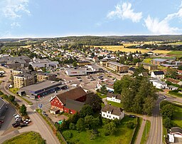
Sem, Norge
| Sem | |
| Ort | |
| Land | |
|---|---|
| Fylke | Vestfold fylke |
| Kommun | Tønsbergs kommun |
| Koordinater | 59°16′45″N 10°19′40″Ö / 59.27917°N 10.32778°Ö |
| Folkmängd | 2 706 (2022)[1] |
| Tidszon | CET (UTC+1) |
| - sommartid | CEST (UTC+2) |
| Postnummer | 3170 SEM |
| Tätortskod | 2631 |
| Geonames | 3139819 |
(c) Karte: NordNordWest, Lizenz: Creative Commons by-sa-3.0 de Ortens läge i Vestfold fylke | |
(c) Karte: NordNordWest, Lizenz: Creative Commons by-sa-3.0 de Vestfold fylke i Norge | |
| Wikimedia Commons: Sem (Tønsberg) | |
Redigera Wikidata | |
Sem är en tätort i Norge, belägen huvudsakligen i Tønsbergs kommun, Vestfold fylke, men med en liten andel (58 inv) i Sandefjords kommun. Orten tillkom som stationssamhälle 1881, då Vestfoldbanan byggdes.

Referenser
- ^ Tettsteders befolkning og areal (på norskt bokmål), Statistisk sentralbyrå, läs online.[källa från Wikidata]
Media som används på denna webbplats
Författare/Upphovsman: Gutten på Hemsen, Licens: CC0
Flag of Norway with colors from the previous version on Commons. This file is used to discuss the colors of the Norwegian flag.
Shiny red button/marker widget. Used to mark the location of something such as a tourist attraction.
Författare/Upphovsman: Trond Strandsberg, Licens: CC BY-SA 3.0
Picture of Sem church (Vestfold - Norway)
Författare/Upphovsman: Senkaledras, Licens: CC BY-SA 4.0
Oversiktsbilde Semsbyen, august 2019, sett fra øst mot vest. Foto: Erik Hesby Johnsen (Luna Media)
(c) Karte: NordNordWest, Lizenz: Creative Commons by-sa-3.0 de
Location map of Vestfold, Norway
(c) Karte: NordNordWest, Lizenz: Creative Commons by-sa-3.0 de
Location of county Vestfold in Norway (2024)


