Selje
| Selje | |
| Ort | |
| Land | |
|---|---|
| Fylke | Vestland fylke |
| Kommun | Stads kommun |
| Höjdläge | 10 m ö.h. |
| Koordinater | 62°2′39″N 5°20′50″Ö / 62.04417°N 5.34722°Ö |
| Area | 0,65 km² |
| Folkmängd | 735 (2019)[1] |
| Befolkningstäthet | 1 130 inv./km² |
| Tidszon | CET (UTC+1) |
| - sommartid | CEST (UTC+2) |
| Tätortskod | 5691 |
| Geonames | 3139914 |
(c) Karte: NordNordWest, Lizenz: Creative Commons by-sa-3.0 de Ortens läge i Vestland fylke | |
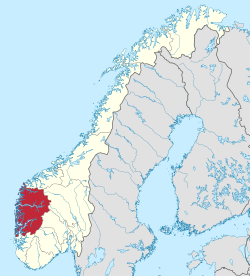
(c) Karte: NordNordWest, Lizenz: Creative Commons by-sa-3.0 de Vestland fylke i Norge | |
| Wikimedia Commons: Selje | |
Redigera Wikidata | |
Selje är en tätort och kyrkby i Stads kommun i Vestland fylke i västra Norge. Orten ligger där fylkesväg 618 möter fylkesväg 619 och fylkesväg 5752, på västra sidan av halvön Stad. Här finns Selje kyrka.[2]
Orten utgjorde tidigare centralort i dåvarande Selje kommun.

Referenser
- ^ Tettsteders befolkning og areal (på norskt bokmål), Statistisk sentralbyrå, läs online.[källa från Wikidata]
- ^ ”Norgeskart”. norgeskart.no. https://norgeskart.no/. Läst 21 februari 2024.
Media som används på denna webbplats
Författare/Upphovsman: Gutten på Hemsen, Licens: CC0
Flag of Norway with colors from the previous version on Commons. This file is used to discuss the colors of the Norwegian flag.
Shiny red button/marker widget. Used to mark the location of something such as a tourist attraction.
(c) Karte: NordNordWest, Lizenz: Creative Commons by-sa-3.0 de
Location map of Vestland, Norway
(c) Karte: NordNordWest, Lizenz: Creative Commons by-sa-3.0 de
Location of county Vestland in Norway (2024)
Författare/Upphovsman: Wolfmann, Licens: CC BY-SA 4.0
Selje kirke 16. september 2014
Författare/Upphovsman: Bjørn Inge Berge, Licens: CC BY 2.0
View over Moldefjord to Selje, Selja and Stad.


