Sedgefield (distrikt)
| Sedgefield | |
| Före detta distrikt | |
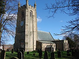
(c) Bill Henderson, CC BY-SA 2.0 | |
| Land | |
|---|---|
| Riksdel | England |
| Ceremoniellt grevskap | Durham |
| Enhetskommun | Durham |
| Folkmängd | 87 206 (2001) |
| Tidszon | UTC (UTC+0) |
| - sommartid | BST (UTC+1) |
Contains Ordnance Survey data © Crown copyright and database right, CC BY-SA 3.0 Läge i Durham | |
Sedgefield var mellan 1974 och 2009 ett distrikt i grevskapet Durham, England. Distriktet har 87 206 invånare (2001).[1] År 2009 blev distriktet en del av enhetskommunen Durham.
Civil parishes
- Bishop Middleham, Bradbury and the Isle, Chilton, Cornforth, Ferryhill, Fishburn, Great Aycliffe, Middridge, Mordon, Sedgefield, Shildon, Spennymoor, Trimdon och Windlestone.[2]
Referenser
- ^ ONS. ”Area: Sedgefield (Former Local Authority)”. Neighbourhood statistics. http://neighbourhood.statistics.gov.uk/dissemination/LeadKeyFigures.do?a=7&b=276946&c=Sedgefield&d=13&e=15&g=440662&i=1001x1003x1032x1004&m=0&r=1&s=1475406880212&enc=1. Läst 2 oktober 2016.
- ^ ”Area selected: Sedgefield (Non-Metropolitan District)”. Neighbourhood statistics. Arkiverad från originalet den 4 mars 2016. https://web.archive.org/web/20160304215853/http://www.neighbourhood.statistics.gov.uk/dissemination/viewFullDataset.do?instanceSelection=03070&productId=779&$ph=60_61&datasetInstanceId=3070&startColumn=1&numberOfColumns=4&containerAreaId=790377. Läst 2 oktober 2016.
Media som används på denna webbplats
Contains Ordnance Survey data © Crown copyright and database right, CC BY-SA 3.0
Map of County Durham, UK with Sedgefield highlighted.
Equirectangular map projection on WGS 84 datum, with N/S stretched 170%(c) Bill Henderson, CC BY-SA 2.0
St Edmund's parish church, Sedgefield, County Durham, seen from the southwest


