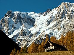
Schweiziska alperna
| Den här artikeln behöver källhänvisningar för att kunna verifieras. (2015-08) Åtgärda genom att lägga till pålitliga källor (gärna som fotnoter). Uppgifter utan källhänvisning kan ifrågasättas och tas bort utan att det behöver diskuteras på diskussionssidan. |
| Bergskedja | Alperna | |
|---|---|---|
| Land | Schweiz | |
| Koordinater | 46°30′0″N 8°30′0″E | |
| Högsta punkt | Dufourspitze | |

Med sitt läge i Alperna finns det många höga bergstoppar i Schweiz. I kantonen Valais återfinns Schweiz högsta berg, Dufourspitze 4 634 m ö.h..
| Topp | Höjd | Kanton | |
|---|---|---|---|
| 1 | Dufourspitze | 4 634 m | Valais |
| 2 | Nordend | 4 609 m | Valais |
| 3 | Zumsteinspitze | 4 563 m | Valais |
| 4 | Signalkuppe | 4 556 m | Valais |
| 5 | Dom | 4 545 m | Valais |
| 6 | Liskamm | 4 527 m | Valais |
| 7 | Weisshorn | 4 505 m | Valais |
| 8 | Taeschhorn | 4 490 m | Valais |
| 9 | Matterhorn | 4 478 m | Valais |
| 10 | Parrotspitze | 4 436 m | Valais |
Externa länkar
 Wikimedia Commons har media som rör Schweiziska Alperna.
Media som används på denna webbplats
Författare/Upphovsman: Tkgd2007, Licens: CC BY-SA 3.0
A new incarnation of Image:Question_book-3.svg, which was uploaded by user AzaToth. This file is available on the English version of Wikipedia under the filename en:Image:Question book-new.svg
Icon of simple gray pencil. An icon for Russian Wikipedia RFAR page.
Författare/Upphovsman: Anna Belial, Licens: CC BY-SA 4.0
A photograph of the Muttbach-River
The 2.5 km high eastern wall of the Dufourspitze (4634 metres, 15 200 feet). The true summit lies in the middle right, between the Signalkuppe (4554 metres) on the left and the Nordend (4609 metres) on the right.


