Scariff
| Scarriff (An Scairbh) | |
| Scariff | |
| Ort | |
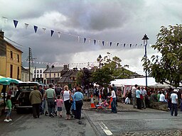
Scarriff hamnfestival. | |
| Land | |
|---|---|
| Provins | Munster |
| Grevskap | An Clár |
| Koordinater | 52°54′31″N 8°31′59″V / 52.90872°N 8.53316°V |
| Tidszon | UTC (UTC+0) |
| - sommartid | BST (UTC+1) |
| Geonames | 2961574 |
Läge i Irland | |
Scariff (iriska: An Scairbh) är en liten stad i östra delen av grevskapet Clare på mellersta Irland. Scariff har ett aktivt musikliv samt marknad och midsommarfestival.
Externa länkar
Media som används på denna webbplats
Shiny red button/marker widget. Used to mark the location of something such as a tourist attraction.
Författare/Upphovsman: The original uploader was Dark-Fire på engelska Wikipedia., Licens: CC BY-SA 3.0
Author: Mark Hogan
Description: A photo from the Scarriff harbour festival 2007. The area shown in the photo is generally considered to be the centre of the town because there is a car park (underneath the marquee on the right), it is a large junction and it is effectly the central business district of the town. The market house, considered to be the symbol of the town, can be seen in the background.
Författare/Upphovsman: Nilfanion, Licens: CC BY-SA 3.0
Relief location map of Ireland
Equirectangular map projection on WGS 84 datum, with N/S stretched 170%
Geographic limits:
- West: 11.0° W
- East: 5.0° W
- North: 55.6° N
- South: 51.2° N


