Santo Ângelo
| Santo Ângelo | |||
| Kommun | |||
Angelopolitanakatedralen i Santo Ângelo. | |||
| |||
| Land | |||
|---|---|---|---|
| Delstat | Rio Grande do Sul | ||
| Koordinater | 28°17′56″S 54°15′46″V / 28.29889°S 54.26278°V | ||
| Area | |||
| - kommun | 680,5 km²[1] | ||
| Folkmängd | |||
| - centralort | 70 963 (1 augusti 2010)[1] | ||
| - kommun | 78 908 (1 juli 2014)[1] | ||
| Befolkningstäthet | |||
| - kommun | 116 invånare/km² | ||
| Geonames | 6323607 | ||
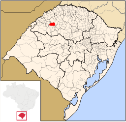
Kommunens läge i delstaten. | |||
| Webbplats: http://www.santoangelo.rs.gov.br/ | |||
Santo Ângelo är en stad och kommun i Brasilien och ligger i delstaten Rio Grande do Sul. Folkmängden i kommunen uppgick år 2014 till cirka 80 000 invånare.
Administrativ indelning
Kommunen var 2010 indelad i femton distrikt:[1]
- Atafona
- Buriti
- Colônia Municipal
- Comandaí
- Cristo Rei
- Lajeado Cerne
- Lajeado Micuim
- Ressaca Buriti
- Restinga Seca
- Rincão dos Mendes
- Rincão dos Meotti
- Rincão dos Roratos
- Santo Ângelo
- Sossego
- União
Källor
- ^ [a b c d] Instituto Brasileiro de Geografia e Estatística, ftp-arkiv med nedladdningsbar statistik Läst 8 februari 2015.
Media som används på denna webbplats
(c) Ricardo630 from en.wikipedia.org, CC BY-SA 3.0
Avbildad plats: Guardian Angel Cathedral
Författare/Upphovsman: Cícero Henrique Rodrigues, Licens: CC BY 2.5
Map locator of Rio Grande do Sul's Santo Ângelo city


