San Sebastián de Yalí
| San Sebastián de Yalí | |
| Yalí | |
| Kommun | |
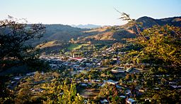
Vy över centralorten | |
| Land | |
|---|---|
| Departement | Jinotega |
| Koordinater | 13°18′20″N 86°11′12″V / 13.305478°N 86.186546°V |
| Centralort | San Sebastián de Yalí |
| Area | 311 km² |
| Folkmängd | 32 441 (2012) |
| Befolkningstäthet | 104 invånare/km² |
| Grundad | 1908 |
| Tidszon | CST (UTC-6) |
| Geonames | 3616571 |
| Känd för[1] | El Salto del Caballo Cerro Yalí Regn |
| Webbplats: INTUR: San Sebastián de Yalí | |
San Sebastián de Yalí, ibland bara Yalí, är en kommun (municipio) i Nicaragua med 20 772 invånare (2012). Den ligger i den norra delen av landet, i departementet Jinotega, mitt emellan Jinotega och Somoto. San Sebastián de Yalí ligger i en bergig trakt med tallskogar och kaffeplantager.[2][3][4]
Geografi
San Sebastián de Yalí gränsar till kommunerna Telpaneca, San Juan del Río Coco och Quilalí i norr, Santa María de Pantasma och San Rafael del Norte i öster, La Concordia i söder, samt till Estelí och Condega i väster.[3]
Historia
San Sebastián de Yalí grundades 1908 och blev 1971 upphöjd från pueblo till rangen av stad (ciudad).[5][6]
Religion
Kommunens festdag är den 20 januari till minne av Sankt Sebastian.[1]
Referenser
- ^ [a b] Juan Echánove och Joaquim Rabella, La guía de Nicaragua, 3a edicón, Editorial Hispamer, 2011.
- ^ Instituto Nacional de Información de Desarrollo, Población Total, estimada al 30 de Junio del año 2012. Arkiverad 2 maj 2013 hämtat från the Wayback Machine.
- ^ [a b] Zonu.com, Mapas Departamentos de Nicaragua
- ^ Instituto Nicaraguense de Turismo, Conocé San Sebastián de Yalí Arkiverad 18 mars 2017 hämtat från the Wayback Machine.
- ^ Normas Jurídicas de Nicaragua, DECRETO POR EL CUAL SE ELEVA Á LA CATEGORÍA DE PUEBLO EL CASERÍO DE SAN SEBASTIÁN DE YALÍ, La Gaceta No. 23, 1908.
- ^ Normas Jurídicas de Nicaragua, ELÉVASE A CATEGORÍA DE CIUDAD AL PUEBLO DE YALÍ, JINOTEGA, La Gaceta No. 83, 1971.
Media som används på denna webbplats
Shiny red button/marker widget. Used to mark the location of something such as a tourist attraction.
Författare/Upphovsman: JOAN PLANAS, Licens: CC BY 2.0
San Sebastián de Yalí, surrounded by hills.
Författare/Upphovsman: Alexrk2, Licens: CC BY-SA 3.0
Physical Location map Nicaragua with Departamentos, Equirectangular projection, N/S stretching 100 %. Geographic limits of the map:


