San Antonio, Florida
| San Antonio | |
| city | |
Stadshuset | |
| Land | |
|---|---|
| Delstat | Florida |
| County | Pasco County |
| Höjdläge | 51 m ö.h. |
| Koordinater | 28°20′10″N 82°16′28″V / 28.33611°N 82.27444°V |
| Yta | 3,4 km² (2010) |
| - land | 3,4 km² |
| - vatten | 0,0 km² |
| Folkmängd | 1 297 (2020)[1] |
| Befolkningstäthet | 381 invånare/km² |
| Tidszon | EST (UTC-5) |
| - sommartid | EDT (UTC-4) |
| ZIP-kod | 33576 |
| Riktnummer | 352 |
| FIPS | 1263375 |
| Geonames | 4171771 |
Ortens läge i Florida | |
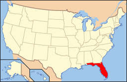
Floridas läge i USA | |
| Webbplats: https://www.sanantonioflorida.org/ | |
San Antonio är en ort i Pasco County i Florida.[2] Vid 2020 års folkräkning hade San Antonio 1 297invånare.[1]
Källor
- ^ [a b] ”San Antonio city, Florida 2020 Decennial Census” (på engelska). United States Census Bureau. https://data.census.gov/profile/San_Antonio_city,_Florida?g=160XX00US1263375. Läst 13 april 2023.
- ^ San Antonio, FL. Map Quest. Läst 22 februari 2020.
|
Media som används på denna webbplats
Shiny red button/marker widget. Used to mark the location of something such as a tourist attraction.
Författare/Upphovsman: Ebyabe, Licens: CC BY-SA 3.0
San Antonio, Florida: City hall
Författare/Upphovsman: This version: en:User:Huebi
Base versions this one is derived from: originally created by en:User:Wapcaplet, Licens: CC BY 2.0
Map of USA with Florida highlighted


