Salem, New Jersey
| Salem, New Jersey | |
| Uppkallad efter: shalom | |
| Land | |
|---|---|
| Delstat | |
| County | Salem County |
| Höjdläge | 3 m ö.h. |
| Koordinater | 39°34′6″N 75°28′21″V / 39.56833°N 75.47250°V |
| Area | 7,29 km² (2010)[2] |
| Folkmängd | 5 296 (2020)[3][4] |
| Befolkningstäthet | 726 invånare/km² |
| Grundad | oktober 1675[1] |
| Tidszon | EST (UTC-5) |
| - sommartid | EDT (UTC-4) |
| ZIP-kod | 08079 |
| Riktnummer | 856 |
| GNIS-kod | 885385 |
| Geonames | 4503944 4503954 |
Översiktskarta | |
| Wikimedia Commons: Salem, New Jersey | |
| Webbplats: http://www.cityofsalemnj.org/ | |
| Redigera Wikidata | |
Salem är administrativ huvudort i Salem County i New Jersey.[5][6] Vid 2010 års folkräkning hade Salem 5 146 invånare.[7]
Kända personer från Salem
- Benjamin H. Brewster, politiker
- Alexander G. Cattell, politiker
- Johnny Gaudreau, ishockeyspelare
Källor
- ^ hämtat från: engelskspråkiga Wikipedia.[källa från Wikidata]
- ^ United States Census Bureau, 2010 U.S. Gazetteer Files, United States Census Bureau, 2010, läst: 9 juli 2020.[källa från Wikidata]
- ^ läs online, www.nj.gov, läst: 22 januari 2022.[källa från Wikidata]
- ^ United States Census Bureau (red.), USA:s folkräkning 2020, läs online, läst: 1 januari 2022.[källa från Wikidata]
- ^ New Jersey County Map with County Seat Cities. Geology.com Geoscience News and Information. Läst 28 december 2019.
- ^ Salem, NJ. Map Quest. Läst 28 december 2019.
- ^ 2010 Census Population of Salem, New Jersey Arkiverad 28 december 2019 hämtat från the Wayback Machine.. Census Viewer. Läst 28 december 2019.
|
Media som används på denna webbplats
Salem Courthouse in Salem, New Jersey, photographed from Market Street. 2nd oldest active courthouse in the US. Entrance is now on Broadway (to the right) but that part of the building was added about 1815. In the NRHP Market Street Historic District in Salem, NJ
|
This is an image of a place or building that is listed on the National Register of Historic Places in the United States of America. Its reference number is 75001157. |
Författare/Upphovsman: Arkyan, Licens: CC BY-SA 3.0
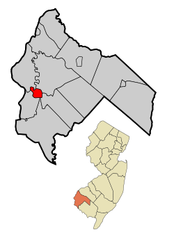
This map shows the incorporated and unincorporated areas in Salem County, New Jersey, highlighting Salem in red. It was created with a custom script with US Census Bureau data and modified with Inkscape.


