Salangens kommun
| Salangens kommun | |||
| Salangen kommune | |||
| Kommun | |||
Sjøvegan | |||
| |||
| Land | |||
|---|---|---|---|
| Fylke | Troms fylke | ||
| Koordinater | 68°54′2″N 17°53′35″Ö / 68.90056°N 17.89306°Ö | ||
| Centralort | Sjøvegan | ||
| Area | 521,56 km² (2020)[4] | ||
| - land | 437,92 km² (2020) | ||
| - vatten | 83,68 km² | ||
| Folkmängd | 2 048 (2023)[5] | ||
| Befolkningstäthet | 5 invånare/km² | ||
| Grundad | 1 januari 1871[1] | ||
| - Utbruten ur | Ibestads kommun (1871)[1] | ||
| - Tillförda områden | Lavangen (1964)[2] | ||
| - Avträdda områden | Lavangens kommun (1977)[2] | ||
| Politik | |||
| - Kommunstyrelsens ordförande | Sigrun W. Prestbakmo (2014–) (Sp)[3] | ||
| Tidszon | CET (UTC+1) | ||
| - sommartid | CEST (UTC+2) | ||
| Kommunkod | 1923 (1977–2019) 5417 (2020–2023) 1921 (–1977) 5522 (2024–) | ||
| Geonames | 3140541 | ||
| Målform | bokmål och nynorska | ||
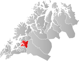
 Salangens kommun i Troms fylke. | |||
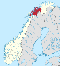
(c) Karte: NordNordWest, Lizenz: Creative Commons by-sa-3.0 de Troms fylke i Norge. | |||
| Wikimedia Commons: Salangen | |||
| Webbplats: https://www.salangen.kommune.no/ | |||
| Redigera Wikidata | |||
Salangens kommun (norska: Salangen kommune) är en kommun i Troms fylke i norra Norge. Kommunens centralort är tätorten Sjøvegan.
Administrativ historik
Salangens kommun bildades 1871 genom en delning av Ibestads kommun. 1964 gick Lavangens kommun upp i Salangens kommun. 1977 delades de två kommunerna igen.[6]
Tätorter
I Salangens kommun finns en tätort:[7]
- Sjøvegan (centralort)
Socknar
Inom Norska kyrkan motsvaras Salangens kommun av Salangens socken i Senja prosteri i Nord-Hålogalands stift.[8]

Referenser
- ^ [a b] Dag Juvkam, Historisk oversikt over endringer i kommune- og fylkesinndelingen, Statistisk sentralbyrå, maj 1999, s. 80, ISBN 82-537-4684-9, läs online.[källa från Wikidata]
- ^ [a b] Dag Juvkam, Historisk oversikt over endringer i kommune- og fylkesinndelingen, Statistisk sentralbyrå, maj 1999, s. 81, ISBN 82-537-4684-9, läs online.[källa från Wikidata]
- ^ Politisk ledelse (på norskt bokmål), läs online.[källa från Wikidata]
- ^ Statens kartverk, Arealstatistikk for Norge 2020, Statens kartverk, 20 december 2019, läs online.[källa från Wikidata]
- ^ 07459: Alders- og kjønnsfordeling i kommuner, fylker og hele landets befolkning (K) 1986 - 2023 (på norskt bokmål), Statistisk sentralbyrå, 21 februari 2023, läs online.[källa från Wikidata]
- ^ Historisk oversikt over endringer i kommune- og fylkesinndelingen, Dag Juvkam, Statistisk sentralbyrå, 1999, ISBN 82-537-4684-9.
- ^ Kart fra Statistisk sentralbyrå
- ^ Store norske leksikon
Externa länkar
- Officiell webbplats
 Wikimedia Commons har media som rör Salangens kommun.
| ||||||||||
Media som används på denna webbplats
Författare/Upphovsman: Gutten på Hemsen, Licens: CC0
Flag of Norway with colors from the previous version on Commons. This file is used to discuss the colors of the Norwegian flag.
(c) Karte: NordNordWest, Lizenz: Creative Commons by-sa-3.0 de
Location of county Troms in Norway (2024)
Coat of arms for the norwegian county of Troms.
Författare/Upphovsman: Sigmund Pettersen Zig 21:04, 8 January 2006 (UTC), Licens: CC BY-SA 2.5
The picture shows Sjøvegan, the administrative centre of Salangen municipality in Troms county in Norway, and the surrounding areas. The inner part of the Salangen fjord, Sagfjorden lies in front of Sjøvegan, and to the right Nervatn and a part of Øvervatn is visible. The picture is taken from Høgfjellet, the second highest mountain in the municipality, more than 1200 metres above sea level.
Författare/Upphovsman: Zig, Licens: CC BY-SA 3.0
The picture shows the view from the Northwest of Mjøsundet between Ibestad and Salangen in Troms, Norway. The bridge is named Mjøsundbrua. The fjord towards the left of the picture is named Salangen, and after turning right it is called Sagfjorden. The slightly visible fjord on the far right of the picture is Lavangen. The mountains on the other side of Sagfjorden are from left to right: Høgfjellet, Rundkollen (Lifjellet), Elveskardtindan and Reitetindan.
Författare/Upphovsman: Jay1279, Licens: CC0
Map of Salangen Municipality in Troms county, Norway
Flag of Salangen municipality
Kommunevåpen for Salangen kommune i Troms fylke.


