Saint-Sulpice-la-Pointe
| Saint-Sulpice | ||
| Kommun | ||
.png) | ||
| ||
| Land | ||
|---|---|---|
| Region | Occitanien | |
| Departement | ||
| Arrondissement | Castres | |
| Kanton | Lavaur | |
| Koordinater | 43°47′N 1°41′Ö / 43.783°N 1.683°Ö | |
| Yta | 23,99 km²[1] | |
| Folkmängd | 9 576 ()[2] | |
| Befolkningstäthet | 399 invånare/km² | |
| Postnummer | 81370 | |
| INSEE | 81271 | |
| Geonames | 6617799 2976879 | |
| OSM-karta | 144552 | |
 (c) NordNordWest, CC BY-SA 3.0 Kommunens läge i regionen Occitanien i Frankrike | ||
| Webbplats: http://www.saintsulpicelapointe.fr | ||

Saint-Sulpice är en kommun i departementet Tarn i regionen Occitanien i södra Frankrike. Kommunen ligger i kantonen Lavaur som tillhör arrondissementet Castres. År 2021 hade Saint-Sulpice 9 576 invånare.
Befolkningsutveckling
Antalet invånare i kommunen Saint-Sulpice
 Referens: INSEE[3] |
Pozoruhodné miesta a pamiatky
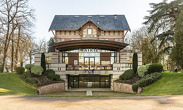 Radnica
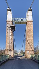 Visutý most cez Agout.
 Vojnový pamätník.
 Dovecote z roku 1810
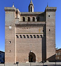 Kostol Notre-Dame
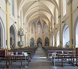 Pohľad na loď
Se även
Källor
- ^ Répertoire géographique des communes, Institut national de l'information géographique et forestière, läst: 26 oktober 2015, licens: öppen licens.[källa från Wikidata]
- ^ Populations légales 2021, Institut National de la Statistique et des Études Économiques, 28 december 2023.[källa från Wikidata]
- ^ Chiffres clés - Évolution et structure de la population hämtat från the Wayback Machine (arkiverat 4 maj 2012).
Externa länkar
 Wikimedia Commons har media som rör Saint-Sulpice-la-Pointe.
Media som används på denna webbplats


Författare/Upphovsman: Eric Gaba (Sting - fr:Sting), Licens: CC BY-SA 4.0
Blank physical map of metropolitan France for geo-location purpose.
Scale : 1:14 816 000 (accuracy : about 3,7 km) for the bathymetry. More maps of France, view → Commons Atlas of France.

Shiny red button/marker widget. Used to mark the location of something such as a tourist attraction.
_-_Pigeonnier_de_1810.jpg)
Författare/Upphovsman: Didier Descouens, Licens: CC BY-SA 4.0
Saint-Sulpice-la-Pointe - dovecote tower 1810
Författare/Upphovsman:
|
Map data (c) OpenStreetMap contributors, CC-BY-SA _French_municipality_map.svg) • Shape files infrastructure: railway, highways, water: all originally by OpenStreetMap contributors. Status december 2011 *note: shown commune boundaries are from OSM dump May 2012; at that time about 90% complete |
Map of French municipality Saint-Sulpice
.svg)
Författare/Upphovsman: Michiel1972, Licens: CC BY-SA 3.0
Population - Municipality code 81271.svg
Population Census 1962-2008Författare/Upphovsman: Teeppix, Licens: CC BY 3.0
Vue aérienne de Saint-Sulpice (Tarn) depuis un Aquila AT01 F-GZPL.

Blason (non-officiel attendu que ce département ne revendique aucun blason) du département du Tarn :
« D’or au chef-pal de gueules chargé d'une croix clêchée, vidée et pommetée de douze pièces d’or »
_-_Eglise_Notre-Dame_-_Interieur.jpg)
Författare/Upphovsman: Didier Descouens, Licens: CC BY-SA 4.0
Saint-Sulpice-la-Pointe, Tarn France - Church of Our Lady
_-_Monument_aux_Morts.jpg)
Författare/Upphovsman: Didier Descouens, Licens: CC BY-SA 4.0
Saint-Sulpice-la-Pointe - War memorials
_-_Mairie.jpg)
Författare/Upphovsman: Didier Descouens, Licens: CC BY-SA 4.0
Saint-Sulpice-la-Pointe, Tarn, France - Town hall
_-_le_pont_suspendu_sur_l%27Agout.jpg)
Författare/Upphovsman: Didier Descouens, Licens: CC BY-SA 4.0
Saint-Sulpice-la-Pointe the suspension bridge over Agout. Completed in 1849, it was initially toll. The bridge was swept away by the flood of 1930, and rebuilt since 1931, the last restorations date from 2000.
_-_Eglise_Notre-Dame_-_Clocher-mur.jpg)
Författare/Upphovsman: Didier Descouens, Licens: CC BY-SA 4.0
Saint-Sulpice-la-Pointe, Tarn France - Bell gable of the church of Church of Our Lady