Saint-Michel-de-Chaillol
| Saint-Michel-de-Chaillol | |
| Kommun | |
 | |
| Land | |
|---|---|
| Region | Provence-Alpes-Côte d'Azur |
| Departement | |
| Arrondissement | Gap |
| Kanton | Saint-Bonnet-en-Champsaur |
| Koordinater | 44°40′N 6°10′Ö / 44.667°N 6.167°Ö |
| Yta | 16,78 km²[1] |
| Folkmängd | 361 ()[2] |
| Befolkningstäthet | 22 invånare/km² |
| Tidszon | CET (UTC+1) |
| - sommartid | CEST (UTC+2) |
| Postnummer | 05260 |
| INSEE | 05153 |
| Geonames | 2977998 |
| OSM-karta | 971980 |
 (c) NordNordWest, CC BY-SA 3.0 Kommunens läge i regionen Provence-Alpes-Côte d'Azur i Frankrike | |
| Webbplats: https://www.mairie-chaillol.fr/ | |

Saint-Michel-de-Chaillol är en kommun i departementet Hautes-Alpes i regionen Provence-Alpes-Côte d'Azur i sydöstra Frankrike. Kommunen ligger i kantonen Saint-Bonnet-en-Champsaur som ligger i arrondissementet Gap. År 2021 hade Saint-Michel-de-Chaillol 361 invånare.
Befolkningsutveckling
Antalet invånare i kommunen Saint-Michel-de-Chaillol
Referens:INSEE[3]
Galleri

 Skidbacken
Se även
- Lista över kommuner i departementet Hautes-Alpes
 Wikimedia Commons har media som rör Saint-Michel-de-Chaillol.
Källor
- ^ Répertoire géographique des communes, Institut national de l'information géographique et forestière, läst: 26 oktober 2015, licens: öppen licens.[källa från Wikidata]
- ^ Populations légales 2021, Institut National de la Statistique et des Études Économiques, 28 december 2023.[källa från Wikidata]
- ^ Chiffres clés - Évolution et structure de la population Arkiverad 5 juli 2012 hämtat från the Wayback Machine.
Media som används på denna webbplats


parti, en 1 de gueules à la croix cléchée, vidée et pommetée de douze pièces d’or et en 2 d’or au dauphin d’azur crêté, barbé, loré, peautré et oreillé de gueules; au chef d’azur semé de fleurs de lys d’or

Författare/Upphovsman: Eric Gaba (Sting - fr:Sting), Licens: CC BY-SA 4.0
Blank physical map of metropolitan France for geo-location purpose.
Scale : 1:14 816 000 (accuracy : about 3,7 km) for the bathymetry. More maps of France, view → Commons Atlas of France.

Shiny red button/marker widget. Used to mark the location of something such as a tourist attraction.

Författare/Upphovsman: Lapenne, Licens: CC BY-SA 3.0
pistes de ski de chaillol en été
Författare/Upphovsman:
|
Map data (c) OpenStreetMap contributors, CC-BY-SA _French_municipality_map.svg) • Shape files infrastructure: railway, highways, water: all originally by OpenStreetMap contributors. Status december 2011 *note: shown commune boundaries are from OSM dump May 2012; at that time about 90% complete |
Map commune FR insee code 05153.png

Författare/Upphovsman: yann, Licens: CC BY-SA 3.0
Monument aux morts pour la France, aux Marrons

Författare/Upphovsman: yann, Licens: CC BY-SA 3.0
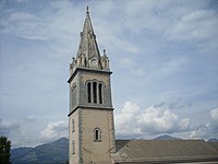
Clocher de l'église Saint-Pierre de Saint-Michel-de-chaillol

Författare/Upphovsman: Lapenne, Licens: CC BY-SA 3.0
route reliant le hameau des marrons (hautes-alpes) au village de Saint-Michel-de-Chaillol (hautes-alpes).