Saint-Martin-de-Ré
| Saint-Martin-de-Ré | ||
| Kommun | ||
 Vy över Saint-Martin-de-Ré | ||
| ||
| Land | ||
|---|---|---|
| Region | Nouvelle-Aquitaine | |
| Departement | ||
| Arrondissement | La Rochelle | |
| Kanton | Île de Ré | |
| Koordinater | 46°12′6″N 1°22′5″V / 46.20167°N 1.36806°V | |
| Yta | 4,7 km²[1] | |
| Folkmängd | 2 309 ()[2] | |
| Befolkningstäthet | 491 invånare/km² | |
| Tidszon | CET (UTC+1) | |
| - sommartid | CEST (UTC+2) | |
| Postnummer | 17410 | |
| INSEE | 17369 | |
| Geonames | 6428097 2978361 | |
| OSM-karta | 112857 | |
 Kommunens läge i regionen Nouvelle-Aquitaine i Frankrike | ||
| Webbplats: https://www.saint-martin-de-re.fr/ | ||

Saint-Martin-de-Ré är en kommun i departementet Charente-Maritime i regionen Nouvelle-Aquitaine i västra Frankrike. Kommunen ligger i kantonen Île de Ré som ligger i arrondissementet La Rochelle. År 2022 hade Saint-Martin-de-Ré 2 309 invånare. Saint-Martin-de-Ré ligger på ön Île de Ré.
Befolkningsutveckling
| Befolkningsutvecklingen i Saint-Martin-de-Ré 1968–2021[3] | ||||
|---|---|---|---|---|
| År | Folkmängd | |||
| 1968 | 2 096 | |||
| 1975 | 2 135 | |||
| 1982 | 2 400 | |||
| 1990 | 2 512 | |||
| 1999 | 2 637 | |||
| 2007 | 2 588 | |||
| 2015 | 2 346 | |||
| 2021 | 2 263 | |||
Bildgalleri

 (c) I, LeZibou, CC BY-SA 3.0
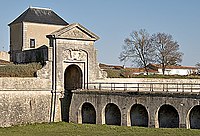


Se även
Källor
- ^ Répertoire géographique des communes, Institut national de l'information géographique et forestière, läst: 26 oktober 2015.[källa från Wikidata]
- ^ Populations légales 2022, Institut National de la Statistique et des Études Économiques, 19 december 2024.[källa från Wikidata]
- ^ ”Historique des populations légales – Recensements de la population 1968–2021” (på franska). www.insee.fr. Institut national de la statistique et des études économiques (INSEE). 28 december 2023. https://www.insee.fr/fr/statistiques/2522602. Läst 22 augusti 2024.
Media som används på denna webbplats

Författare/Upphovsman: Eric Gaba (Sting - fr:Sting), Licens: CC BY-SA 4.0
Blank physical map of metropolitan France for geo-location purpose.
Scale : 1:14 816 000 (accuracy : about 3,7 km) for the bathymetry. More maps of France, view → Commons Atlas of France.

Shiny red button/marker widget. Used to mark the location of something such as a tourist attraction.
.svg)
Författare/Upphovsman: unknown, Licens: CC BY-SA 3.0
(c) I, LeZibou, CC BY-SA 3.0
Saint Martin de Ré (Ile de Ré, Charente-Maritime, France) : église Saint Martin : vestiges du croisillon sud du transept vus depuis le clocher.

Författare/Upphovsman: The original uploader was Pep.per på franska Wikipedia., Licens: CC BY-SA 1.0
Maison familiale de Nicolas Baudin à Saint Matin de Ré - Île de Ré
Photo issue de ma banque d'images personnelle www.imagesdile.com

Författare/Upphovsman: The original uploader was Pep.per på franska Wikipedia., Licens: CC BY-SA 1.0
Porte des Campani, fossé, bastion, corps de garde à Saint-Martin-de-Ré - île de Ré
Photo issue de ma banque d'images personnelle : www.imagesdile.com

Författare/Upphovsman: Original uploader was Pep.per at fr.wikipedia, Licens: CC BY-SA 3.0
Le port de fr:Saint-Martin-de-Ré vu des remparts, photo personnelle de Françoise Thurion alias Accrochoc, prise le 26 août 2001. Appareil numérique de marque Olympus type Camedia 1400 (1,4M pixels)
Författare/Upphovsman:
|
Map data (c) OpenStreetMap contributors, CC-BY-SA _French_municipality_map.svg) • Shape files infrastructure: railway, highways, water: all originally by OpenStreetMap contributors. Status december 2011 *note: shown commune boundaries are from OSM dump May 2012; at that time about 90% complete |
Map commune FR insee code 17369.png

Författare/Upphovsman: The original uploader was Pep.per på franska Wikipedia., Licens: CC BY-SA 1.0
L'Hôtel de Clerjotte - Musée Ernest Cognacq - Saint-Martin-de-Ré - Île de Ré Photo issue de mon site : http://perso.wanadoo.fr/all.web/musee

Författare/Upphovsman: The original uploader was Pep.per på franska Wikipedia., Licens: CC BY-SA 1.0
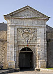
La Porte de la citabelle de Saint-Martin-de-Ré - Île de Ré - Charente-Maritime
Photo issue de ma banque d'images : www.imagesdile.com
Alain - Pep.per 24 septembre 2006 à 16:08 (CEST)
Författare/Upphovsman: The original uploader was Pep.per på franska Wikipedia., Licens: CC BY-SA 1.0
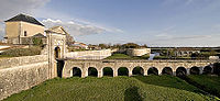
Porte de La Couarde, dite des Campani à Saint-Martin-de-Ré - Île de Ré
Photo issue de la banque d'images : www.imagesdile.com

Författare/Upphovsman: User:Brice~commonswiki, Licens: CC BY-SA 3.0
Saint-Martin de Ré, France