Saint-Martin-d'Entraunes
| Saint-Martin-d'Entraunes | |
| Kommun | |
 | |
| Land | |
|---|---|
| Region | Provence-Alpes-Côte d'Azur |
| Departement | |
| Arrondissement | Nice |
| Kanton | Guillaumes |
| Koordinater | 44°8′N 6°46′Ö / 44.133°N 6.767°Ö |
| Yta | 40,05 km²[1] |
| Folkmängd | 146 ()[2] |
| Befolkningstäthet | 4 invånare/km² |
| Borgmästare | Jean-Claude Autheman (2020–)[3] |
| Tidszon | CET (UTC+1) |
| - sommartid | CEST (UTC+2) |
| Postnummer | 06470 |
| INSEE | 06125 |
| Geonames | 6425675 2978363 |
| OSM-karta | 1466904 |
 Kommunens läge i regionen Provence-Alpes-Côte d'Azur i Frankrike. | |

Saint-Martin-d'Entraunes är en kommun i departementet Alpes-Maritimes i regionen Provence-Alpes-Côte d'Azur i sydöstra Frankrike. Kommunen ligger i kantonen Guillaumes som ligger i arrondissementet Nice. År 2022 hade Saint-Martin-d'Entraunes 146 invånare.
Befolkningsutveckling
Antalet invånare i kommunen Saint-Martin-d'Entraunes
Referens: INSEE[4]
Galleri

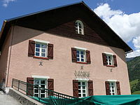 Rådhuset
 Kyrkan Saint-Martin
 Kapellet Saint-Guilhen
Se även
Källor
- ^ Répertoire géographique des communes, Institut national de l'information géographique et forestière, läst: 26 oktober 2015.[källa från Wikidata]
- ^ Populations légales 2022, Institut National de la Statistique et des Études Économiques, 19 december 2024.[källa från Wikidata]
- ^ Répertoire national des élus du 2 décembre 2020, 2 december 2020.[källa från Wikidata]
- ^ Chiffres clés - Évolution et structure de la population Arkiverad 5 juli 2012 hämtat från the Wayback Machine.
Media som används på denna webbplats

Författare/Upphovsman: Eric Gaba (Sting - fr:Sting), Licens: CC BY-SA 4.0
Blank physical map of metropolitan France for geo-location purpose.
Scale : 1:14 816 000 (accuracy : about 3,7 km) for the bathymetry. More maps of France, view → Commons Atlas of France.

Shiny red button/marker widget. Used to mark the location of something such as a tourist attraction.
Författare/Upphovsman:
|
Map data (c) OpenStreetMap contributors, CC-BY-SA _French_municipality_map.svg) • Shape files infrastructure: railway, highways, water: all originally by OpenStreetMap contributors. Status december 2011 *note: shown commune boundaries are from OSM dump May 2012; at that time about 90% complete |
Map commune FR insee code 06125.png
.JPG)
Författare/Upphovsman: MOSSOT, Licens: CC BY-SA 3.0
Saint-Martin-d'Entraunes et la vallée du Var
Författare/Upphovsman: MOSSOT, Licens: CC BY-SA 3.0
Saint-Martin-d'Entraunes - Vue du village à partir de la route du col des Champs

Författare/Upphovsman: MOSSOT, Licens: CC BY-SA 3.0
Saint-Martin-d'Entraunes - Mairie

Författare/Upphovsman: Ipankonin, Licens: CC BY-SA 3.0
Coat of arms of the counts of the County of Nice, and the current Alpes-Maritimes Department: Argent, an eagle displayed crowned gules standing upon three rocks vert issuing from the sea azure in base.

Författare/Upphovsman: MOSSOT, Licens: CC BY-SA 3.0
Saint-Martin-d'Entraunes - L'église Saint-Martin et le clocher

Författare/Upphovsman: MOSSOT, Licens: CC BY-SA 3.0
Saint-Martin-d'Entraunes - Eglise Saint-Martin et clocher

Författare/Upphovsman: MOSSOT, Licens: CC BY-SA 3.0
Saint-Martin-d'Entraunes - Chapelle Saint-Guilhen

Författare/Upphovsman: MOSSOT, Licens: CC BY-SA 3.0
Saint-Martin-d'Entraunes - Aiguilles de Pelens vues de la route du col des Champs