Sagamihara
| Sagamihara (相模原市) | |
| Stad | |
| Land | |
|---|---|
| Region | Kantō |
| Prefektur | Kanagawa |
| Koordinater | 35°34′N 139°22′Ö / 35.567°N 139.367°Ö |
| Area | 328,66 km²[1] |
| Folkmängd | 720 914 (1 oktober 2015)[1] |
| Befolkningstäthet | 2 193 invånare/km² |
| Borgmästare | Kentarō Motomura (2019–) |
| Geonames | 1853293 |
| Träd | Zelkova serrata[2] |
| Fågel | Sånglärka[2] |
| Blomma | Hortensia[2] |
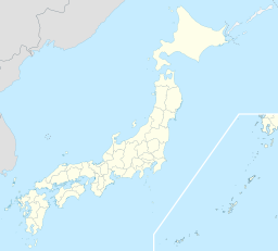
 Sagamiharas läge i Japan | |
| Webbplats: http://www.city.sagamihara.kanagawa.jp/ | |

Sagamihara(japanska: 相模原市?, Sagamihara-shi) är en stad i Kanagawa prefektur i Japan. Sagamihara ingår i Tokyos storstadsområde.[3]
Den 25 juli 2016 dödades 19 personer och 26 skadades i en knivattack på ett vårdhem för handikappade i staden.[4]
Administrativ indelning
Sagamihara är sedan 2010 en av landets numera tjugo signifikanta städer med speciell status (seirei shitei toshi).[5] och delas som sådan in i ku, administrativa stadsdelar. Sagamihara består av tre sådana stadsdelar.
| Invånare 1 oktober 2015[1] | Area (km²)[1] | ||
|---|---|---|---|
| Chūō-ku | 中央区 | 270 021 | 36,87 |
| Midori-ku | 緑区 | 173 710 | 253,68 |
| Minami-ku | 南区 | 277 183 | 38,11 |
Noter
- ^ [a b c d] ”Japansk sida med invånarantal och ytor”. Masahiro Higashide. http://uub.jp/cpf/kanagawa.html. Läst 23 augusti 2016.
- ^ [a b c] läs online, www.city.sagamihara.kanagawa.jp .[källa från Wikidata]
- ^ Publikation 2005 Population Census of Japan, Overview Series No.9; Population of Major Metropolitan Areas, Statistics Bureau, Ministry of Internal Affairs and Communications, Japan; ISBN 978-4-8223-3577-9.
- ^ McCurry, Justin (26 juli 2016). ”Japan Knife Attack: Stabbing at Care Centre Leaves 19 Dead and Dozens Wounded”. The Guardian (Guardian News and Media). https://www.theguardian.com/world/2016/jul/25/tokyo-knife-attack-stabbing-sagamihara. Läst 25 augusti 2016.
- ^ ”Japansk sida med lista över signifikanta städer”. Masahiro Higashide. http://uub.jp/cpf/seirei.html. Läst 21 augusti 2016.
Media som används på denna webbplats
Författare/Upphovsman: Maximilian Dörrbecker (Chumwa), Licens: CC BY-SA 3.0
Location map of Japan
Equirectangular projection.
Geographic limits to locate objects in the main map with the main islands:
- N: 45°51'37" N (45.86°N)
- S: 30°01'13" N (30.02°N)
- W: 128°14'24" E (128.24°E)
- E: 149°16'13" E (149.27°E)
Geographic limits to locate objects in the side map with the Ryukyu Islands:
- N: 39°32'25" N (39.54°N)
- S: 23°42'36" N (23.71°N)
- W: 110°25'49" E (110.43°E)
- E: 131°26'25" E (131.44°E)
Shiny red button/marker widget. Used to mark the location of something such as a tourist attraction.
Författare/Upphovsman:
- File:Usugatake-hirugatake.JPG by User:Σ64
- File:Gate 1 of Sagami Genaral Depot in 2011.jpg by User:Nikm
- File:Sagamiko -01.jpg by User:Aimaimyi
- File:Hashimoto, Sagamihara.jpg by User:Phronimoi
- File:Odakyu Sagami-Ono Station Square 01.jpg by ja:利用者:S.fukasawa (Japanese Wikipedia), Uploaded by User:Fjkelfeimvvn
- File:Astro-E2 in the Clean Room.jpeg by NASA, Uploaded by User:サヤ
- File:Sakura Festival 2009 in Sagamihara 1.jpg by Suneko, Uploaded by User:Halfd
- Composition by User:Fjkelfeimvvn
Sagamihara City, Kanagawa Prefecture, JAPAN
From top left:Tanzawa mountains, USARJ Sagami General Depot, Lake Sagami, Hashimoto District, Odakyu Sagami-Ōno Station, JAXA Sagamihara Campus, Sakura Festival
South Entrance and elevated walkway at JR Sagamihara Station on the Yokohama Line in Sagamihara, Kanagawa, Japan


