Sabalan
| Sabalan (سبلان) | |
| Berg | |
| Land | |
|---|---|
| Provins | Ardabil |
| Koordinater | 38°16′05″N 47°50′06″Ö / 38.268°N 47.835°Ö |
| Högsta punkt | |
| - höjdläge | 4 784 m ö.h.[1] |
| Tidszon | IRST (UTC+3:30) |
| - sommartid | IRDT (UTC+4:30) |
| Geonames | 118105 |
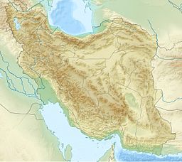
Läge i Iran | |
Sabalan (persiska: سبلان) är ett berg i nordvästra Iran, i provinsen Ardabil. Det är en stratovulkan, som verkar ha varit aktiv in på senare delen av pleistocen. Det finns dock inga säkra tecken på att den varit aktiv även senare, under holocen.[1] Sju glaciärer sträcker sig ner längs sluttningarna på berget, vars topp befinner sig 4 784 meter över havet.[1]
Källor
Externa länkar
 Wikimedia Commons har media som rör Sabalan.
Media som används på denna webbplats
Flag of Iran. The tricolor flag was introduced in 1906, but after the Islamic Revolution of 1979 the Arabic words 'Allahu akbar' ('God is great'), written in the Kufic script of the Qur'an and repeated 22 times, were added to the red and green strips where they border the white central strip and in the middle is the emblem of Iran (which is a stylized Persian alphabet of the Arabic word Allah ("God")).
The official ISIRI standard (translation at FotW) gives two slightly different methods of construction for the flag: a compass-and-straightedge construction used for File:Flag of Iran (official).svg, and a "simplified" construction sheet with rational numbers used for this file.
Shiny red button/marker widget. Used to mark the location of something such as a tourist attraction.
Författare/Upphovsman: Uwe Dedering, Licens: CC BY-SA 3.0
Topographic map of the Iranian plateau in Central Asia, connecting to Anatolia in the west and Hindu Kush and Himalaya in the east.


