Sørreisa
| Sørreisa | |
| Ort | |
| Land | |
|---|---|
| Fylke | Troms fylke |
| Kommun | Sørreisa kommun |
| Höjdläge | 8 m ö.h. |
| Koordinater | 69°8′41″N 18°9′10″Ö / 69.14472°N 18.15278°Ö |
| Area | |
| - tätort | 1,64 km² |
| - kommun | 362,95 km² (2020) |
| Folkmängd | |
| - tätort | 1 566 (2019)[2] |
| - kommun | 3 428 (2023)[1] |
| Befolkningstäthet | |
| - tätort | 950 inv./km² |
| - kommun | 9 inv./km² |
| Tidszon | CET (UTC+1) |
| - sommartid | CEST (UTC+2) |
| Tätortskod | 8091 |
| Geonames | 7626403 |
(c) Karte: NordNordWest, Lizenz: Creative Commons by-sa-3.0 de Ortens läge i Troms fylke | |
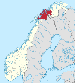
(c) Karte: NordNordWest, Lizenz: Creative Commons by-sa-3.0 de Troms fylke i Norge | |
Redigera Wikidata | |
Sørreisa är en tätort i Sørreisa kommun i Troms fylke i norra Norge. Orten ligger längst inne i Reisafjorden,där fylkesväg 84 möter fylkesväg 86.[3] Den utgör kommunens centralort såväl som största tätort.
Referenser
- ^ 07459: Alders- og kjønnsfordeling i kommuner, fylker og hele landets befolkning (K) 1986 - 2023 (på norskt bokmål), Statistisk sentralbyrå, 21 februari 2023, läs online.[källa från Wikidata]
- ^ Tettsteders befolkning og areal (på norskt bokmål), Statistisk sentralbyrå, läs online.[källa från Wikidata]
- ^ Norgeskart.no
Media som används på denna webbplats
Författare/Upphovsman: Gutten på Hemsen, Licens: CC0
Flag of Norway with colors from the previous version on Commons. This file is used to discuss the colors of the Norwegian flag.
Shiny red button/marker widget. Used to mark the location of something such as a tourist attraction.
Författare/Upphovsman: Bjoertvedt, Licens: CC BY-SA 3.0
Aerial view from the east towards west, over Sørreisa and Lenvik municipalities, with Reisafjord in the foreground, Solbergfjord to the upper left, Finnfjord to the upper right, and Senja Island in the background - central Troms county (Norway)
(c) Karte: NordNordWest, Lizenz: Creative Commons by-sa-3.0 de
Location map of Troms, Norway
(c) Karte: NordNordWest, Lizenz: Creative Commons by-sa-3.0 de
Location of county Troms in Norway (2024)


