Rushcliffe District
| Rushcliffe District | |
| Distrikt | |
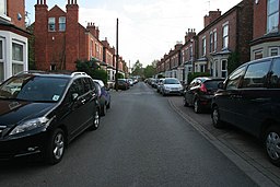
(c) Kate Jewell, CC BY-SA 2.0 | |
| Land | |
|---|---|
| Riksdel | England |
| Region | East Midlands |
| Ceremoniellt grevskap | Nottinghamshire |
| Administrativt grevskap | Nottinghamshire |
| Koordinater | 52°55′N 1°02′V / 52.91°N 1.04°V |
| Administrativ huvudort | West Bridgford |
| Area | 409 km²[1] |
| Folkmängd | 121 582 (2022)[2] |
| Befolkningstäthet | 297 invånare/km² |
| Tidszon | UTC (UTC+0) |
| - sommartid | BST (UTC+1) |
| GSS-kod | E07000176 |
| Geonames | 7290619 |
Läge i Nottinghamshire | |
Rushcliffe District är ett distrikt (motsvarande kommun) i grevskapet Nottinghamshire i England, Storbritannien. Distriktet har 121 582 invånare (2022)[2]. Större orter är Bingham och West Bridgford. Distriktet är indelat i 60 civil parishes, förutom staden West Bridgford som inte ingår i någon civil parish.
Källor
- ^ ”Estimates of the population for the UK, England, Wales, Scotland, and Northern Ireland (Mid-2022)” (på engelska) (xls). Landyta, avrundad till hela km². Office for National Statistics. 26 mars 2024. https://www.ons.gov.uk/peoplepopulationandcommunity/populationandmigration/populationestimates/datasets/populationestimatesforukenglandandwalesscotlandandnorthernireland. Läst 25 juni 2024.
- ^ [a b] ”Estimates of the population for the UK, England, Wales, Scotland, and Northern Ireland (Mid-2022)” (på engelska) (xls). Office for National Statistics. 26 mars 2024. https://www.ons.gov.uk/peoplepopulationandcommunity/populationandmigration/populationestimates/datasets/populationestimatesforukenglandandwalesscotlandandnorthernireland. Läst 25 juni 2024.
| |||||||||||
Media som används på denna webbplats
(c) Kate Jewell, CC BY-SA 2.0
Stratford Road, West Bridgford. During the fast growth of Nottingham in the Victorian period pressure was put on the Musters Family, who owned much of the land in West Bridgford, to allow suburban development south of the River Trent. Eventually the Musters sold their land, but they put in place strict planning regulations to the area then known as the West Bridgford Estate. This development was planned over a grid of tree lined streets. The main roads such as Musters Road (see 1267593) had restrictions on the density of housing and house size. Smaller houses were permitted on side streets, and terraces were erected on roads such as Stratford Road for the servants of the wealthy Nottingham merchants who bought up the larger properties. It is interesting to note that there are no "Streets" in West Bridgford. Originally many roads were name "Street" but this was felt to be too urban by the Victorian "planners". Thus all street names were changed from "Street" to "Road". The one exception is "Village Street" in Edwalton, a village that has been totally absorbed into the town of West Bridgford.
Författare/Upphovsman:
- Nottinghamshire UK district map (blank).svg: Nilfanion, created using Ordnance Survey data
- derivative work: Renly (talk)
Map of Nottinghamshire, with Rushcliffe highlighted.


