Ruokojaure
| Land | |
|---|---|
| Län | Norrbottens län |
| Kommun | Arjeplogs kommun |
| Landskap | Lappland |
| Socken | Arjeplogs socken |
| Koordinater | |
| WGS 84 | 65°48′33″N 18°20′37″Ö / 65.80910°N 18.34368°Ö |
| SWEREF 99 TM | 7302701, 652834 |
| Flöden | |
| Huvudavrinningsområde | Skellefteälvens huvudavrinningsområde (20000) |
| Övrigt | |
| SjöID | 730327-161611 |
| Limnisk ekoregion | Norrlands inland, under trädgränsen över högsta kustlinjen |
Ruokojaure är en sjö i Arjeplogs kommun i Lappland och ingår i Skellefteälvens huvudavrinningsområde.
Se även
Källor
Externa länkar
| Denna sjöartikel är maskinellt skapad och ett samarbete mellan Wikipedia och VISS. Du kan se hur artikeln är gjord på sidan Projekt Sveriges sjöar och diskutera utformningen på diskussionssidan. Fler maskinellt skapade sjöartiklar finns i kategorin robotskapade sjöartiklar. När innehållet har kontrollerats kan mallen tas bort. |
Media som används på denna webbplats
Författare/Upphovsman: Silverkey (Mickaël Delcey), Licens: CC BY-SA 4.0
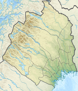
Topographic location map of Norrbotten county in Sweden
Equirectangular projection, N/S stretching 257 %. Geographic limits of the map:
- N: 69.10° N
- S: 64.90° N
- W: 15.10° E
- E: 24.30° E
Shiny red button/marker widget. Used to mark the location of something such as a tourist attraction.
Författare/Upphovsman: Mikadiou, Licens: CC BY-SA 3.0
opened laptop computer, brown screen


