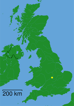
Rugby, Storbritannien
| Rugby | |
| stad | |
Rugby i juli 2005 | |
| Land | |
|---|---|
| Riksdel | England |
| Region | West Midlands |
| Ceremoniellt grevskap | Warwickshire |
| Administrativt grevskap | Warwickshire |
| Distrikt | Rugby |
| Koordinater | 52°22′12″N 1°15′36″V / 52.37000°N 1.26000°V |
| Folkmängd | 70 628 (2011) |
| Tidszon | GMT (UTC+0) |
| Postort | RUGBY |
| Postnummerområde | CV21, CV22, CV23 |
| Riktnummer | 01788 |
| Geonames | 2638978 |

Rugby är den näst största staden i Warwickshire, ett grevskap i mellersta England i Storbritannien. Invånarna uppgick 2011 till 70 628 i antalet.[1] Staden nämndes i Domedagsboken (Domesday Book) år 1086, och kallades då Rocheberie.[2]
Bollsporten Rugby uppkom i denna stad. I Rugby möts de viktiga motorvägarna M1 och M6.
Källor
Fotnoter
- ^ p ”Rugby (Warwickshire)” (på engelska). Rugby on City Population. http://www.citypopulation.de/php/uk-england-westmidlands.php?cityid=E35001272 p. Läst 22 mars 2015.
- ^ ”Warwickshire Q-Z”. The Domesday Book Online. http://www.domesdaybook.co.uk/warwickshire3.html#rugby. Läst 6 november 2022.
Externa länkar
 Wikimedia Commons har media som rör Rugby, Storbritannien.
| ||||||||
Media som används på denna webbplats
Författare/Upphovsman: Alexrk2, Licens: CC BY-SA 3.0
Location map of the United Kingdom
Shiny red button/marker widget. Used to mark the location of something such as a tourist attraction.
The town centre of Rugby. The clock tower in the centre dates from 1887 and was built to mark the golden jubilee of Queen Victoria. At the left of the picture is the market place.
Taken by G-Man July 2005.


