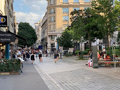
Rue Montmartre
 | |
| Arrondissement | 1:a, 2:a |
|---|---|
| Kvarter | Halles Vivienne |
| Börjar vid | Rue Rambuteau och Rue Montorgueil |
| Slutar vid | Boulevard Montmartre och Boulevard Poissonnière |
| Längd | 939 meter |
| Bredd | 15 meter |
| Invigd | cirka 1200 |
| Tidigare namn | Rue de la Porte de Montmartre |
Rue Montmartre är en gata i Quartier des Halles, Quartier Vivienne och Quartier du Mail i Paris första och andra arrondissement. Gatan är uppkallad efter Montmartre. Rue Montmartre börjar vid Rue Rambuteau och Rue Montorgueil 1 och slutar vid Boulevard Montmartre 1 och Boulevard Poissonnière 29.
Omgivningar
- Saint-Eustache
- Rue Étienne-Marcel
- Rue du Louvre
- Rue Réaumur
- Rue d'Uzès
- Placette Louvre-Montmartre
- Place Ghislaine-Dupont-Claude-Verlon-Camille-Lepage
Bilder
|
|
Kommunikationer
 Tunnelbana – linjerna
 – Grands Boulevards
 Busshållplats Réaumur – Montmartre – Paris bussnät, linjerna 74 85 N15 N16
Referenser
- Den här artikeln är helt eller delvis baserad på material från franskspråkiga Wikipedia, Rue Montmartre, 31 maj 2022.
Webbkällor
- ”Rue Montmartre”. Mairie de Paris. https://web.archive.org/web/20160303192356/http://www.v2asp.paris.fr/commun/v2asp/v2/nomenclature_voies/Voieactu/6444.nom.htm. Läst 2 augusti 2022.
- ”Rue Montmartre”. Les rues de Paris. https://web.archive.org/web/20180307000429/http://www.parisrues.com/rues01/paris-01-rue-montmartre.html. Läst 2 augusti 2022.
Externa länkar
 Wikimedia Commons har media som rör Rue Montmartre.
Media som används på denna webbplats
Paris Metro logo
Transit icon for Line 9 of the Paris Métro. See {{Paris transit icons}} for colour standards.
- own work
- line-art inspired by contemporary metro plans
Författare/Upphovsman:
- Paris street enseigne top.gif: EyOne
- derivative work: Beao (diskussion)
Image taken from en:Image:Paris street enseigne top.gif, uploaded by en:user:ThePromenader with the following description: my own work - J.M. Schomburg www.paris-promenades.com ==
Författare/Upphovsman: Chabe01, Licens: CC BY-SA 4.0
Rue Montmartre, Paris.
Transit icon for Line 8 of the Paris Métro. See {{Paris transit icons}} for colour standards.
- own work
- line-art inspired by contemporary metro plans
(c) Eric Gaba, Wikimedia Commons user Sting, CC BY-SA 3.0
Blank land cover map of the city and department of Paris, France, as in January 2012, for geo-location purpose, with distinct boundaries for departments and arrondissements.
Författare/Upphovsman:
- Paris enseigne tr.svg:
- Paris enseigne tr.gif: EyOne
- derivative work: Beao
- derivative work: Svgalbertian (diskussion)
Bottom right corner of rue Paris infobox
Författare/Upphovsman:
- Paris enseigne tr.svg:
- Paris enseigne tr.gif: EyOne
- derivative work: Beao
- derivative work: Svgalbertian (diskussion)
Bottom left corner of rue Paris infobox
Författare/Upphovsman: Mbzt, Licens: CC BY-SA 3.0
Montmartre street on the Plan of Truschet and Hoyau (1550).
Författare/Upphovsman: Pavel Krok, Licens: CC BY-SA 2.5
Église Saint-Eustache à Paris
Författare/Upphovsman: Chabe01, Licens: CC BY-SA 4.0
Place Ghislaine Dupont - Claude Verlon - Camille Lepage, Paris.
Författare/Upphovsman:
- Paris enseigne tr.gif: EyOne
- derivative work: Beao (diskussion)
Top right corner of rue Paris infobox
Författare/Upphovsman:
- Paris enseigne tr.gif: EyOne
- derivative work: Beao
- derivative work: Svgalbertian (diskussion)
Top left corner of rue Paris infobox
Författare/Upphovsman: Chabe01, Licens: CC BY-SA 4.0
Plaque de la rue Montmartre, Paris.


