Roquefort-sur-Soulzon
| Roquefort-sur-Soulzon | ||
| Kommun | ||
 | ||
| ||
| Land | ||
|---|---|---|
| Region | Occitanien | |
| Departement | ||
| Arrondissement | Millau | |
| Kanton | Saint-Affrique | |
| Koordinater | 43°59′N 2°59′Ö / 43.983°N 2.983°Ö | |
| Yta | 17,03 km²[1] | |
| Folkmängd | 502 ()[2] | |
| Befolkningstäthet | 29 invånare/km² | |
| Tidszon | CET (UTC+1) | |
| - sommartid | CEST (UTC+2) | |
| Postnummer | 12250 | |
| INSEE | 12203 | |
| Geonames | 6427004 2982856 | |
| OSM-karta | 76036 | |
 Kommunens läge i regionen Occitanien i Frankrike. | ||

Roquefort-sur-Soulzon är en kommun i departementet Aveyron i regionen Occitanien i södra Frankrike. Kommunen ligger i kantonen Saint-Affrique som ligger i arrondissementet Millau. År 2022 hade Roquefort-sur-Soulzon 502 invånare. I kommunen lagras blåmögelosten Roquefort.
Befolkningsutveckling
Antalet invånare i kommunen Roquefort-sur-Soulzon
Referens: INSEE[3]
Galleri
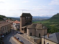 Vy över staden och kyrkan
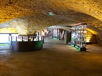 Källare med ostförsäljning
Se även
Externa länkar
 Wikimedia Commons har media som rör Roquefort-sur-Soulzon.
Källor
- ^ Répertoire géographique des communes, Institut national de l'information géographique et forestière, läst: 26 oktober 2015.[källa från Wikidata]
- ^ Populations légales 2022, Institut National de la Statistique et des Études Économiques, 19 december 2024.[källa från Wikidata]
- ^ Chiffres clés - Évolution et structure de la population Arkiverad 5 juli 2012 hämtat från the Wayback Machine.
Media som används på denna webbplats

Författare/Upphovsman: Eric Gaba (Sting - fr:Sting), Licens: CC BY-SA 4.0
Blank physical map of metropolitan France for geo-location purpose.
Scale : 1:14 816 000 (accuracy : about 3,7 km) for the bathymetry. More maps of France, view → Commons Atlas of France.

Shiny red button/marker widget. Used to mark the location of something such as a tourist attraction.

Författare/Upphovsman: ByacC, Licens: CC BY-SA 3.0
Blason : D'argent, à la tour de sable, accompagnée au premier canton d'une croix fleuronnée et fichée du même.

.jpg)
Författare/Upphovsman: Budotradan, Licens: CC BY-SA 3.0
cave de roquefort
Författare/Upphovsman:
|
Map data (c) OpenStreetMap contributors, CC-BY-SA _French_municipality_map.svg) • Shape files infrastructure: railway, highways, water: all originally by OpenStreetMap contributors. Status december 2011 *note: shown commune boundaries are from OSM dump May 2012; at that time about 90% complete |
Map commune FR insee code 12203.png

.jpg)
Författare/Upphovsman: Budotradan, Licens: CC BY-SA 3.0
le village et son église
Författare/Upphovsman: Dan Karran, Licens: CC BY-SA 2.5
Photo of Roquefort-sur-Soulzon, France