Romedal
| Romedal | |
| Ort | |
| Land | |
|---|---|
| Fylke | Innlandet fylke |
| Kommun | Stange kommun |
| Koordinater | 60°45′0″N 11°16′0″Ö / 60.75000°N 11.26667°Ö |
| Area | |
| - tätort | 0,49 km² (2019)[3] |
| - kommun | 385 km² (1964)[1] |
| Folkmängd | |
| - tätort | 663 (2019)[3] |
| - kommun | 6 441 (1964)[2] |
| Befolkningstäthet | |
| - tätort | 1 350 inv./km² |
| - kommun | 17 inv./km² |
| Tidszon | CET (UTC+1) |
| - sommartid | CEST (UTC+2) |
| Tätortskod | 1056 |
| Geonames | 3141433 |
(c) Karte: NordNordWest, Lizenz: Creative Commons by-sa-3.0 de Ortens läge i Innlandet fylke | |
(c) Karte: NordNordWest, Lizenz: Creative Commons by-sa-3.0 de Innlandet fylke i Norge | |
| Wikimedia Commons: Romedal | |
Redigera Wikidata | |
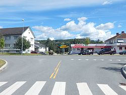
Romedal är en tätort i Stange kommun i Innlandet fylke i östra Norge. Orten har tidigare utgjort centralort i dåvarande Romedals kommun i Hedmark fylke.
Referenser
- ^ Store norske leksikon.[källa från Wikidata]
- ^ Dag Juvkam, Historisk oversikt over endringer i kommune- og fylkesinndelingen, Statistisk sentralbyrå, maj 1999, ISBN 82-537-4684-9, läs online.[källa från Wikidata]
- ^ [a b c] Tettsteders befolkning og areal (på norskt bokmål), Statistisk sentralbyrå, läs online.[källa från Wikidata]
Media som används på denna webbplats
Författare/Upphovsman: Gutten på Hemsen, Licens: CC0
Flag of Norway with colors from the previous version on Commons. This file is used to discuss the colors of the Norwegian flag.
(c) Karte: NordNordWest, Lizenz: Creative Commons by-sa-3.0 de
Location map of Innlandet, Norway
Shiny red button/marker widget. Used to mark the location of something such as a tourist attraction.
Författare/Upphovsman: Jan-Tore Egge, Licens: CC BY-SA 4.0
Krysset i Romedal sentrum mellom Mågårdvegen (fylkesvei 1900, tidl. 231) og Solvinvegen
(c) Karte: NordNordWest, Lizenz: Creative Commons by-sa-3.0 de
Location of county Innlandet in Norway (2024)


