Rome, New York
| Rome | |
| Stad (city) | |
| Land | |
|---|---|
| Delstat | |
| County | Oneida County |
| Höjdläge | 139 m ö.h. |
| Koordinater | 43°13′10″N 75°27′48″V / 43.21944°N 75.46333°V |
| Area | 195,81 km² (2010)[2] |
| Folkmängd | 32 127 (2020)[3] |
| Befolkningstäthet | 164 invånare/km² |
| Grundad | 1870[1] |
| Tidszon | EST (UTC-5) |
| - sommartid | EDT (UTC-4) |
| ZIP-kod | 13440 |
| Riktnummer | 315 |
| GNIS-kod | 962840 |
| Geonames | 5134295 5134301 |
Översiktskarta | |
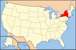
New Yorks läge i USA | |
| Wikimedia Commons: Rome, New York | |
| Webbplats: http://romenewyork.com/ | |
| Redigera Wikidata | |
Rome är en stad (city) i Oneida County i delstaten New York.[4] Vid 2010 års folkräkning hade Rome 32 850 invånare.[5]
Källor
- ^ hämtat från: engelskspråkiga Wikipedia.[källa från Wikidata]
- ^ United States Census Bureau, 2010 U.S. Gazetteer Files, United States Census Bureau, 2010, läst: 9 juli 2020.[källa från Wikidata]
- ^ United States Census Bureau (red.), USA:s folkräkning 2020, läs online, läst: 1 januari 2022.[källa från Wikidata]
- ^ Rome, NY. Map Quest. Läst 4 juli 2021.
- ^ 2010 Census Population of Rome, New York Arkiverad 9 juli 2021 hämtat från the Wayback Machine.. Census Viewer. Läst 4 juli 2021.
Externa länkar
 Wikimedia Commons har media som rör Rome.
Media som används på denna webbplats
Photograph of the 1851 Oneida County Courthouse in Rome, New York. The architecture is in the Greek Revival style that was popular in Upstate New York in the 19th century. This courthouse replaced one built in 1801 that had burned down in 1848.
Författare/Upphovsman: Huebi, Licens: CC BY 2.0
Map of USA with New York highlighted
Författare/Upphovsman: Buffaboy, Licens: CC BY-SA 4.0
Map showing the location of Rome within Oneida County, New York. Data source: http://www2.census.gov/geo/maps/dc10map/tract/st36_ny/c36065_oneida/


